Thursday, May 30, 2013

the minimalist

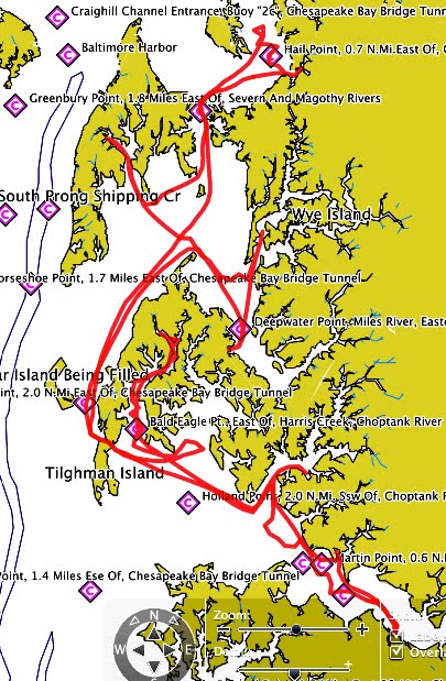
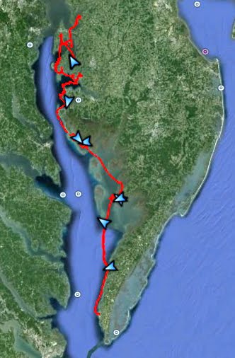
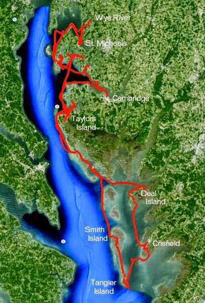
I have to run over to the Eastern Shore for work this weekend.  I kind of like being able to say that.  There are far worse places to go for work.


The destination is the town of Onancock.  Things have worked out such that I will have Spartina in tow and will get to do some sailing on Onancock Creek, spending a night anchored on a smaller creek.  Yes, this is work.  Somebody has to do it.


This is an interesting event for me.  Typically I either day sail or go for a multiple-day cruise.  This is somewhere in between.  I need more than what I take for a daysail, less than what I take for a week long cruise.  I am paring things down, figuring out the minimal amount of gear for being comfortable and safe overnight.  Bivy?  Yes.  Stove?  No. Cook kit? No.  Food - just snacks really, I'll be eating my meals in some of Onancock's better restaurants (on the company dime no less).  Change of clothes?  Yes, I would like to be presentable.  Light kit?  No, but I do need to bring along an anchor light.  Thermals? No.  Basic safety gear?  Yes, that is always on board.  EPIRB?  No.  SPOT?  Maybe - but I won't be using the tracking function when sailing on a four mile long creek.  Eight gallons of bottled water?  No, but I'll have plenty of 12 oz. bottles of water on board.  Boom tent?  Not with a weekend forecast of clear skies.


This is a nice little challenge for me - figure out what I need for a night or two and be ready to throw my gear in the duffle bag and do a quick trip.  Why not enjoy all those little creeks, rivers and bays that line Chesapeake Bay and the sounds of North Carolina.  Something to sleep in, something to snack on. Why not?  See a nice weekend forecast?  Grab the basics and enjoy an overnight trip. 

I just need to remember that I am working.  Should you be out on Onancock Creek this weekend and see a yawl with a green hull, please say hello.

steve


Tuesday, May 28, 2013

Back Bay


That's a classic old sharpie being rebuilt alongside the marshes of Back Bay.  

Monday, May 27, 2013

one fine day

A boat named this post about Sunday's sail.


One candidate for a title would have been this weathered ketch, above and below, called PRECIOUS TIMES.  That could have been a description for the day, but maybe it is a better description of the time I get to spend out on the water on Spartina.

I was up before 6, out on the water by 7:30.  Clear skies and cool enough for an extra layer of clothing, with a steady northwest wind.  I motored down past bridge and raised sail off the Waterside Marina then headed to Crawford Bay to visit the fleet of six or eight snow birds.

Precious Times, anchored with the fleet, appears to be a local boat.  I hope to see it again during the season.  The smallest sailboat on the bay, you can see she needs not only varnish but also some tender loving care.  I expect she will get both.

After an hour and a half sailing solo I pulled into Freemason Harbor to pick up my friend Jim for a morning sail.  I had not seen him in a long while and we had to catch up on the Navigator he is building and the Schooner Virginia, for which he crews.


Late morning we sailed back to Freemason Harbor where I dropped off Jim and picked up my co-worker Aaron and his son Monroe for an afternoon sail.  Kate, the wife/mom, was running late, we picked her up an hour later on the Portsmouth waterfront.

The steady breeze continued, the day warmed and we sailed with a steady stream of snowbirds heading north.  Monroe, at the ripe age of two, has been out on Spartina three times now, each time feeling more comfortable on the boat.  I don't know what was more fun - watching Monroe enjoy being on the boat or watching his parents delight in his joy.  
 

It was one of those beautiful days on the water, the kind that is perfect to share with friends.  Breezy, not too hot and a rich blue sky.

Late morning it was this ketch above that summed up the day - ONE FINE DAY, out of Dungannon, heading north on the ICW.

There is a Dungannon, Virginia, but it is well inland.  I suspect this boat comes from a Dungannon farther north, possibly the one in Canada.  I watched them coming around the river bend past Portsmouth and timed my crossing to pass close by so I could get a better look at the pretty boat.  They were looking back at Spartina too.  We waved, I took a photograph, the woman made a gesture as if she were taking a photograph and shouted a greeting that was lost to the wind.  But they were kind enough to leave behind an apt description of the day.  Thank you, One Fine Day, for that.

steve

Saturday, May 25, 2013

all is not lost

Could it be that the Webb Chiles story has made it to the big screen?


I just today heard of a film titled All is Lost, starring Robert Redford.  The film, at least according to IMDB, is the story of one man's fight to survive.  According to the trailer he does so on the open ocean, single handing a 30-some foot sloop.  


Above you see the listing of the entire cast.  Yes, a cast of one.  You better like Robert Redford if you are going to see this film.  And you had better enjoy silence.   According to the reviewer there are about ten lines of dialogue.  Or should I say monologue. 


The reviewer absolutely loved the film.  We'll see.  But couldn't they have found somebody younger (Redford is 76 years old) and better looking to portray Webb?

(And I think Webb would have looked around for a storm before climbing the mast.)

steve

ps - the wife disagrees on the "better looking" reference above.....

Friday, May 24, 2013

happy to be on the water

There is Dawn, appearing to be loving life as she sails Dawn Patrol with Paul somewhere on the Pungo River (I think) this morning.


They are out for a little sailing vacation, plus scouting for this fall's Pamlico Challenge.  Below is the proposed route.  I suspect they are sailing up the Pungo River and will then follow the canal north to the Alligator River and Albemarle Sound.  You can follow their SPOT track here.


It looks like beautiful weather down there.  And it should be nice weather up here this coming weekend.  I should be out on the river Sunday.  Can't wait.

steve

Thursday, May 23, 2013

downrigging weekend, friends on the water

It's just the beginning of the summer sailing season but I'm already thinking about the end of the year.  But that's just planning.


I received an email from the Sultana Project, the Chestertown, MD group that operates the Sultana, about their annual downrigging weekend.  It was an invitation to take part in the event.  Tall ships, small classic boats - I'm there.  I attended in 2011, a cold and windy affair.  I missed last year, trapped on Hatteras Island during Hurricane Sandy.  I do want to attend this coming year.  The oldest daughter, living in Maryland, has offered to come over as crew.

-----------------------------------------

Walking through the kitchen each day I pass by our calendar which is clearly marked with a week of "Steve sailing".  That would have been the much abbreviated spring sail.  Each time I notice the marked off dates I shake my head with regret.  This is the first spring in years that I have not spent a week or more out on the water somewhere.  This spring it was one day of great sailing, not the five or six or seven we had planned on.   


I am glad to see that several friends have been on or are on the water.  Above is a nice drawing from Curt as he sailed his Drascombe Longboat "Annie" on the western shore of Chesapeake Bay just about the time Spartina was running into sandbars on the Eastern Shore.  You can read about his trip starting here.  I find his note interesting: "Going to windward off Bluff Point, quartering 4'chop, NE 20-25 knts."  Our high winds on the Eastern Shore were part of that same weather pattern.


Friends Paul, above, and Dawn are sailing Dawn Patrol in the sounds of North Carolina, scouting for this coming fall's NC Pamlico Challenge.  


Paul and Dawn's son Alan, a boat builder working with Graham Byrnes, sailed Southbound in the Okume Festival Ultra Marathon with girlfriend Taylor.  Alan tends to strike a great pose when cameras are near.  You can read about his trip here.  


And Burney sailed his Sea Pearl around the Inner Banks, one of my favorite places, which you can read about here.  

From where I am sitting I can see the calendar with "Steve sailing."  It did not work out for me, but at least I can enjoy other people's adventures.

steve

Monday, May 20, 2013

mist

Here's a very nice Chesapeake Bay scene, one which I have stolen from my friend Curt's blog Thin Water Annie.  He attended, on a misty morning, a boat gathering on the Piankatank River.  I would not be surprised if this image, or one of the others in his post, turns up in his artwork someday.


Driving home over the bridge this evening I noticed there were nearly a dozen sailboats anchored in Crawford Bay.  The snowbirds are finally heading north after a long, cold, wet winter.  The forecast is good this coming weekend and I hope to see several more cruising sailboats on the river.

steve

Sunday, May 19, 2013

laissez les bon temps roulez

Crawfish arrived about 1:30.  Boiling started about 4:30.  Friends began arriving about 5:00.  We started in the backyard but rain drove us inside.  No matter.  


A little bit crowded and a lot of moving platters of food to make room at the table.  Crawfish was in big demand, as was the corn boiled in the crawfish spices, the pasta and fruit salads, chilled shrimp..... not to mention the wine and beer.  And there was the tray full of baklava that our neighbors brought for dessert from the Greek festival in Norfolk.  A very fun evening.

I kind of wish I was sailing today but the weather is unsettled.  And there is some clean up work to do.  But now is the beginning of the summer day sailing season.  The water and air have warmed up (finally).  I'll get out there next week.

steve

Saturday, May 18, 2013

bugs


and beer


and corn, pasta salad, boiled shrimp
and other stuff....

Friday, May 17, 2013

old boats


I've been fooling around lately, taking photographs of old boats in black and white.  Why?  Because it is fun.

The crawfish are on their way.  The weather is trending towards thunderstorms for saturday afternoon.  And of course our air conditioning just went out, won't be repaired until next week.  Hot, humid and rainy - maybe the crawfish boil will be more like New Orleans than we expected.

steve


Wednesday, May 15, 2013

Albemarle and Pamlico Sounds


I came across the photograph above this morning, reminding myself how much I enjoy the sounds of North Carolina.  That's Spartina, with Bruce aboard a few years ago, anchored just off of Wainwright Island in Core Sound.


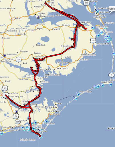
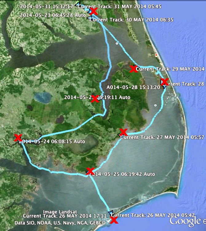
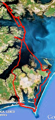
I plan on doing a solo trip this fall, from Elizabeth City going counter clockwise to Belhaven, Hobucken, Cape Lookout, possibly Ocracoke, Wysocking Bay, Manteo and then back to Elizabeth City.  Straight line measurements from google earth show a distance of 338 miles.  Sailing distance will probably be close to 400 miles, maybe more.

I should be doing the trip about the same time as the Watertribe's North Carolina Pamlico Challenge (NCPC), which covers much of same territory save Ocracoke and Elizabeth City.  Maybe I will see a few sails on the horizon, a few paddlers passing by, but I don't expect they will have time to stop say hello.  It is a race, after all.


I have sailed the southern part of the map above, from Belhaven south to Cape Lookout and east to Core Sound.  Sailing to Ocracoke will be new to me, as will Manteo, Albemarle Sound (the body of water between Manteo and Elizabeth City) and the Alligator River.

After our very exciting day sailing downwind on narrow, shallow canals during the one and done 22.8, I will look forward to open, deeper water.  It will be a nice change of pace.

steve

Tuesday, May 14, 2013

crawfish, by the numbers

20 lbs of select crawfish
12 to 15 crawfish per pound


24 hours from swamp to door,


3 lemons
2 tablespoons crab boil
3 packets of seasoning
20 quart pot with steamer basket


2 minutes in boiling water
15 minutes soaking in the spiced hot water
10-15 minutes of steaming in a cooler


10 minutes for boiling potatoes
5 minutes for boiling the corn


a dozen friends and neighbors, maybe more
two daughters coming home to visit

can't wait

steve

Monday, May 13, 2013

before the trip

On the way to Chincoteague we stopped at Sting-Rays (know as Chez Exxon to locals) near Cape Charles for the traditional breakfast sandwich.  There we ran into my friend Bill, who took this photograph and forwarded it to me.  Thanks, Bill.


In 24 hours we would be following the curves of Cat Creek at over four knots under jib along.  In 48 hours we would be driving home, realizing that the Metomkin Island overwash blocked our chance of sailing behind the barrier islands down the Eastern Shore seaside.

It is time for summer day sailing - Bruce and I had a nice day on the Elizabeth River this past Friday - and time to start thinking about the fall solo trip on the sounds of North Carolina.  

So it  

Saturday, May 11, 2013

the one and done 22.8

A crescent moon hangs in the predawn sky as I carry the bag of electronics - SPOTS, gps's and epirb's - down to Spartina.  Temperatures in the mid-40's and a strong north wind, Bruce and I had both dressed in our foul weather gear in the room at the Waterside Inn.  I tuck the gear away and crank up the outboard. 

One more load of gear - our duffles with sleeping bags, hypothermia kits and clothes - and we cast off, motoring the narrow path out of the marina through the stakes marking the shoals.  Mizzen up first, then jib, then turning downwind to ride the outgoing current towards the inlet.  Fighting the tiller I realize there was no need for the mizzen.  Bruce takes the tiller while I lower the small sail and tie it to the mizzen boom.  Not yet dawn and we are making 4.7 kts under jib alone.


The sun creeps up as we reach the south end of Chincoteague, the water rough as the ebb tide flows to the east under the strong north wind.  Our plan had been to sail outside the inlet around the small bit of land called Chincoteague Point, coming back in on the far side of the inlet.  The tide, rushing faster than expected, convinces us to take the shallow route behind Chincoteague Point.

We had been warned the day before that the channel behind the point had shoaled and by 6:30  we are both out of the boat walking Spartina across the sand flats.  With the jib still raised, Bruce and I all slide the hull over the hard sand bottom for about 30 yards.  Spartina skips across the sand and begins to float, Bruce jumps in and I'm right behind him as Spartina heads south towards Wallops Island.


Spartina sails southwest out of the narrows area, the ebb tide flowing from the south building a chop against the north wind.  At marker "5" the water narrows between marshes and the island, the water calms.  There is a light overcast, both the water and sky are grey, the marshes brown.  To the south we can see the launch pads and radar dishes at a NASA site on Wallops Island.  

At 7:15 Spartina sails into Island Hole Narrows, the first of several narrow, winding channels for the day.  Skies clear and it warms up.  I see a bridge to the south that we will need to pass beneath but the channel carries us to the southwest towards the island.  Glancing at the chart and gps I convince myself I had taken a wrong turn and wonder how we will turn back up north into the strong wind.  I call up to Bruce.  He checks his gps and tells me we took the correct channel.  

The marshes, brown near the inlet, are rich green in the shallows.  The water is glassy calm but the wind still blows over 20 mph.  We follow the narrow path at almost four knots, standing on the decks to see if we can recognize the waterway ahead.  There are fewer markers than I would like, just green marker "17" rising out of the grass to mark the channel leading under the bridge.  And even as we pass that marker we cannot see the waterway, only marsh.  Finally the channel curves to starboard to reveal Cat Creek and the passage beneath the bridge. 


South of the bridge we wind past a series of much welcomed markers towards Assawoman Bay.  Narrow guts branch off port and starboard along the way, sand shoals and oyster reefs reach out from shore.  It is beautiful, relaxing sailing.  We track our position on the gps, recognizing along the way that the charts are not completely accurate.  The gps shows a turn south up ahead at marker "26" but I see only small markers for a private channel.  Glancing to port I see a deep, unmarked channel across the marsh.  With a push of the tiller Spartina swings back and makes the cut through the grass into the channel.


At 8:30 we enter a long straight channel, Northam Narrows, just inside of Assawoman Island.  We watch as a bald eagle hovers, then lands in the marsh.  We sail south down the channel at over four knots.

Leaving the narrows we cross Kegotank Bay, turning southwest towards Gargathy Inlet.  The channel will carry us just inside the inlet and we can already hear surf pounding the barrier island.  A white mist, a combination of spray from the surf and windswept sand from the dunes, hovers over the inlet.  


Approaching the inlet I'm surprised at how close we will come to the ocean waters.  Waves break over the shallows, rolling into the channel.  It is a spectacular sight with sand dunes north and south, shoals and surging water.


The wind and the running tide carry us down the channel.  We cling to the marshy shoreline where the water looks deeper.  Bruce calls back that we are making eight knots, four of the knots coming from the rushing tide.  Midway through the inlet we meet the tide rushing from the south and our speed drops to one knot.  We seem to inch along as the jib pulls us through the inlet.  Suddenly an eddy catches Spartina and turns her toward the ocean.  I push the tiller to port, the boat hesitates, swings back south.  I am grateful for the strong wind.


Gradually our speed increases as we move south out of the inlet.  A knot, then two, then back to almost four knots as we leave the rushing tide behind.


It is not yet 10 a.m. and we've covered much more distance than expected.  I tell Bruce that Gargathy Inlet was the biggest challenge, it will be easy sailing from here on out.  It is a serpentine ride through the marsh grass as the waterway curves port and starboard, the channel hidden is the rich brown savanna.


We break out some snacks - beef jerky and crackers - and enjoy the sail south.  Following Crippen Creek we count off markers "65", ""66" and "67".  At marker "68" I look across the marsh with binoculars for "70" and ""71" which will lead us to a shallow area behind Metomkin Island and then on a channel that will carry us south.  


I see only one post, that one with a danger sign.  Bruce looks at his chart and gps, sees the markers there but he cannot find them on the horizon.  He says the danger sign is about where "70" should be.


We follow the creek as it turns southwest, looking for the opening to the south.  Passing by the danger sign I scan the water for an oyster reef or a sunken boat, trying to understand the need for the warning sign.  

The creek runs along the marsh and we watch for the shallow cut.  The creek ends abruptly at a sandy beach.  I turn Spartina into the wind, run up on the beach and Bruce sets out the anchor.  


We look at the charts, look at the sand, realizing that Metomkin Island has been pushed back into our channel south.  There is a narrow gut between the sand and the marsh, bone dry.  A local fisherman walks over from the beach.  I ask about the channel south.  He tells me that at high tide only the smallest boat can make it through the channel.  Looking at Spartina he says we won't make it through.
I ask about any other way south.  He mentions some guts back up Crippen Creek, though they are probably too small for Spartina.  Maybe Gargathy Bay, he says.


The wind, if anything, is picking up.  We drop the jib, put up the mizzen as a steadying sail and motor back towards Gargathy Inlet.  In the wind and chop we can make just a little over a knot.  We pass two cuts into the marsh, neither wide enough for Spartina.  We continue on, passing two larger passages that are shoaled.  At Gargathy Creek we turn west, sail by a couple fishing boats and ask about a passage south to Wachapreague.  People shake their heads, shrug their shoulders.  Nobody knows of a way south.

We sail into Gargathy Bay, shallow at best and very shallow at low tide.  I bring the board and cb up, the strong afternoon winds, gusting over 30 miles an hour, push us across the bay onto a mud flat.  I try to step out of Spartina to push us off, my foot sinks into the mud.  We drift until we drift no more.  Sitting on the mud flat I toss out the anchor.  Stranded, we get out the charts and look at our gps's in search of a way south.  We see only two, the sand-blocked channel on Crippen Creek and then a tiny winding gut through the marsh which is marked as only by a thin blue line, questionable at best for a boat Spartina's size.

Tired and frustrated I fall asleep while waiting for the incoming tide, wondering if Spartina will become one of those derelict boats in the marshes that make for all those wonderful Chesapeake Bay paintings.


Bruce wakes me an hour and a half later.  Spartina is floating in shallow water, but in the high wind she is dragging anchor across the mudflats towards shallower water.  We raise the jib and sail off the flats into deep enough water to put down some cb and rudder.  I start the outboard, the prop quickly getting tangled in seaweed.  Bruce sets out the anchor while I clean the prop.  We motor, get tangled again, set out the anchor, clean the prop.  And then we do that two more times until Spartina is clear of the grass.

We motor to a boat ramp about a mile away.  With no clear passage to the south, too strong of wind to make it back to Chincoteague, a forecast for three more days of wind plus rain and fog, we decide that the trip was over.  Completing the Delmarva circumnavigation will have to wait for another day.

steve


--------------------------------------------------------

The frustration set in the following morning.  We had driven to Cape Charles on our way home.  Standing near the gazebo on the beach I looked out past the shallows to the water we should have been sailing on in a couple of days.  It was foggy, cold and breezy, but the water was calm in the lee of the Eastern Shore.  I wished we were out there.

It was the wind that did us in.  Instead of dropping to 15-20 with gusts to 25 as forecast, the wind stayed at 23 mph with gusts to 33.  The strong wind combined with shallow, narrow waterways means no maneuverability for a yawl.  Downwind is the only way to go.

I sometimes think about the passage at Crippen Creek and wonder if we could have made it at high tide.  I also wonder if we could have tried to make it and found ourselves stranded halfway through the narrow channel, trapped between the sand and the marsh with a falling tide.

We have since talked to a few people about the passage south inside the barrier island.  Some people say it can be done, other say it can't.  Looking at the satellite photos it is clear that Metomkin Island has been pushed to west, possibly by Hurricane Irene or Hurricane Sandy, maybe by both.  It reminds me of the new inlets forming on Hatteras Island, the storm surge battering the island and pushing the sand back to create an opening in the island.


Sailing offshore from Chincoteague Inlet to Wachapreague, then south inside the barrier islands now seems to be the way, maybe the only way, to complete the circumnavigation.  And possibly a fall trip when the ocean waters are warmer and north winds are more consistent.  We'll have to think about that.  And if we plan an offshore trip we'll be sure to have an alternate plan - i.e. a week long sail on the bay - ready to go if the weather is not right for going outside the barrier islands.

So the spring cruise was just a one day sail, not quite 23 miles.  But I will say it was one of the most exciting, beautiful days Spartina has had on the water.  It was not the cruise we had planned, but at the same time there are no complaints here.