Wednesday, October 31, 2012

the crossing


 Just left the alternate ferry docks in Rodanthe Harbor.


It's about a two hour trip to Stumpy Point, then on home.

steve


Tuesday, October 30, 2012

survivor, Hurricane Sandy edition, dinner

Same story, new storm.  Storm comes, storm goes.  Restaurant that caters to locals opens to cater to locals, maybe lets a few non-locals in. 


 Steamed shrimp, steamed clams.  Oysters on the half shell.


Pop's Raw Bar.  Not a tourist spot, just for islanders.  So many in there tonight it was standing room only until we stole a couple of stools.  Then I saw the guy we stole them from and wish I hadn't.  But he didnt' seem to mind.  Then a burger "to go" to take up the road to my friend who has watched out for me for every hurricane since the late 90's.  Got to love the island life.

steve

blue or red? not a political question

There are certain things that need to be decided at the Cape Pines Motel in Buxton this afternoon.


Blue Moon or Red Stripe.  I'm leaning towards Red Stripe, then dinner at Pop's Raw Bar (where we have visited before during hurricane season).

steve

the road home


It looks like we will be taking the ferry.  Maybe tomorrow if the ferry is running.

steve

clean up

The clean up begins at the Shipwreck Grill in Buxton.  An open restaurant...how nice.


I find myself worrying about friends up north; Mary Lou and Fred in Rock Hall, Dave in New Jersey, Marty the dock master in Lewes and the nice people of JP's on the Wharf in Bowers Beach.  I hope they are all doing well this morning.

steve

Monday, October 29, 2012

surf


We are trapped with water on NC 12 a hundred yards to the north of us and about five miles to the south.  Then they need to figure out if the road at the north end of Hatteras is ok, and the bridge too.


Halloween on Hatteras?

stevc

morning tide

Two hours before high tide and the ocean waters were creeping over the dunes in places and running across NC 12, the highway on Hatteras Island.


There is a lot of concern about sound side flooding today, the waters of Pamlico Sound being pushed up over the barrier island.  Some forecasts last night had sound slide flooding from four to seven feet.  We'll see.  Not much rain this morning and from the looks of the radar we may be out of the rain bands from the hurricane.

To all my friends in Maryland, Delaware and New Jersey, be safe and stay dry.

steve

Sunday, October 28, 2012

dawn

Buxton.  That is the ocean water running across NC 12 this morning at high tide.  The ferry heading south shut down yesterday, the road north to the bridge was closed down at 2 a.m.  We are not going anywhere for a while.


Very windy, not as much rain as I expected.  An unusual storm as the island in places is getting both ocean side and sound side flooding.  Usually it is one or the other, no one I have talked to can remember having both at the same time.

steve

Saturday, October 27, 2012

rocking chairs

The wind howls outside the window.  It does not screech, just howls.  Light rain.  Rocking chairs rock in the gale.


I like being on an island, surrounded by water, surrounded by weather.  It should not flood where we are tonight but the hotel owner said there is a high ridge nearby.  "If you hear somebody knockin' on the door in the middle of the night it will be time to move the car."

We'll head down to Hatteras village tomorrow.

steve

Friday, October 26, 2012

storm watch

Sandy is an interesting storm, also a deadly storm.  Over 20 people have died in its path.  The forecast is continually changing.  Earlier today the hurricane was forecast to pass off of the Outer Banks on Monday.  Now it is expected to be offshore Monday, turning inland to the mid-Atlantic on Tuesday.  No doubt the forecast will be different by tomorrow morning.  


Below is part of the reason for Sandy not being a typical storm.  Sandy is moving north in this image.  Off to the left is a trough approaching from the west.  Typically that trough would be a steering current pushing Sandy out to sea, but at the upper right is a low pressure system.  Early next week Sandy will be squeezed between the trough and the low pressure system.  The results?  We'll find out in a few days.

steve

Thursday, October 25, 2012

trending, not for the best

This is not what we want to see.......


Compare it to the map below and you'll see that Sandy - "Sandy, can't you see I'm in misery"* - has a projected path that is curving to the west, not just nicking the Outer Banks but coming in over (possibly) Pamlico Sound and heading towards Virginia, Maryland, Delaware, New Jersey and so on.  There will be an update later tonight for the weather folks.  We'll know more tomorrow.

steve

*lyrics from "Grease" and I didn't even know that John Travolta could sing...

Wednesday, October 24, 2012

oh, Sandy....

I spoke too soon a few weeks ago when I told a friend I was glad we got through hurricane season without a storm.  I'll add that to my list of famous last words.


It is called Hurricane Sandy and I have already heard it referred to as "the perfect storm."  The late season storm (anytime you get a storm name starting with "s" it's going to be a late season event) is not yet the perfect storm but it could become one soon should it meet another weather phenomena coming across the continental U.S.  I'll let Dr. Jeff Masters explain in a quote from his blog...

"models are predicting that Sandy will get caught up by the trough approaching the Eastern U.S., which will inject a large amount of energy into the storm, converting it to a powerful subtropical storm with a central pressure below 960 mb and sustained winds of 60 - 70 mph. Winds of this strength would likely cause massive power outages, as trees still in leaf take out power lines. Also of great concern are Sandy's rains."


Dr. Masters also points out that another huge problem could be storm surge.  Tropical storm force winds could reach out 300 miles from the storm's center causing ocean side flooding as the storm approaches the Outer Banks and then sound side flooding as it moves north.  Add in the fact that Monday will be a full moon with tides at their monthly peak and, well, it could be a mess.


Or maybe not.  These storms are difficult to predict.  I've heard this storm's potential effect compared to that of Hurricane Noel which left five feet of sand sitting on Highway 12, the main road that runs down the barrier Islands.  But a delay in that trough or a shift in the storm's path could change things - for better or for worse.

Storm surge is a threat to narrow, vulnerable Hatteras Island.  Last year Hurricane Irene's storm surge cut through the island in two places - Mirlo Beach, in the photograph above, and again a few miles north at Pea Island.  The Mirlo Beach cut has since been filled in, but the ocean tide still runs freely through the Pea Island cut.  Storm surges seek out the weakest part of the island and quite literally surge over it and often through it.  That narrow cut at Pea Island, which is now crossed by a temporary metal bridge, could be turned into a gaping hole by this coming storm.  The population on Hatteras lives south of Pea Island, the bridge access to the mainland is north of Pea Island.  It would not be the first time the folks on Hatteras were cut off from the mainland by a storm.


I have a lot of friends in Hatteras and I hope things work out for the best.  If I can get my ducks in a row I may go join them for the storm and see what happens.

steve

Tuesday, October 23, 2012

the last leg

I'm way ahead on planning for next spring's part four of the Delmarva circumnavigation.  I wish I could say this is because of diligence on my part, but really it is only because of some good information passed on by a couple of friends.

We would like to sail outside on the ocean from Chincoteague to Wachapreague Inlet, and then most likely outside again from Wachapreague Inlet to Sand Shoal Inlet.  But weather may dictate that we go inside of the barrier islands.  


Should we have to go inside the barrier islands we would have to pass beneath a fixed bridge on the causeway to Wallops Island. Bridges being an issue on this last trip, I had to wonder (worry) about the clearance for the causeway bridge.  Bill solved this quickly with a mention of Activecaptain.com, an interactive cruising guide with information from local sailors.  It took only a minute to look up the bridge in question, finding that it will not be an issue with a clearance of 40 feet.  Thanks Bill for the tip.


Should we go outside, there is the question of the inlets.  These are barrier island inlets with constantly shifting shoals.  Drew, who has quite a bit of experience sailing the Delmarva Peninsula, provided the information below.


"I can assure that Ocean City has the worst tides of the DELMARVA inlets your track considers. Wachapreague and Sand Shoal are both about 2 knots at peak, without the whirlpools, eddies, and foul wave patterns."

"Wachapreague has an unmarked north channel between the sandbar island and shore that is used by the locals, generally smoother and deeper than the marked channel. About 15 feet deep this August."


"I would aim for Sand shoal at slack high tide if possible; even with your draft, it would be more plesant. Make certain you have time to explore Cobb island; eye candy for the wildlife photographer. But watch the access rules (beach nesting)."

Thanks, Drew, for the information.  I am very happy to hear that these inlets won't have the rough waters of the Ocean City and Indian River Inlets.


We've got several months until this next trip, but I'm glad to have some of the basic information here in the blog (which serves as my notebook).  Thanks again Bill and Drew.


steve


Sunday, October 21, 2012


next year

Thinking about sailing trips for next year.....


Spring is completing the Delmarva circumnavigation by sailing from Chincoteague to Cape Charles and then Tangier Sound.  A short trip with a straight line measurement of a little over 150 miles.   Bruce and I are looking at tides so we can part of it outside of the barrier islands of the Eastern Shore.


Fall would be a longer trip, maybe a couple of weeks of solo sailing.  Starting at Elizabeth City on the Pasquotank River, heading south down the Alligator River to Pamlico Sound and Cape Lookout, then Core Sound back to Pamlico Sound, Ocracoke Island, Roanoke Island and - if time allows - maybe a little more exploration of Albemarle Sound.  Possibly early October when the fishing is good and the weather is cooler.  Something to think about this winter.

steve

Saturday, October 20, 2012

on the waterfront

It was a busy day on the waterfront.  Blue skies and very warm, with winds that came and went but filled in very well mid-day.


There was the wine festival with hundreds of people,
 private boats, tour boats and a cruise ship....


the daughters along for the ride.....


followed by friends along for the ride.

The season is getting late.  Maybe five or six more weekends to be on the water, then the off season maintenance begins.  I'm already making a list of jobs.

steve


Friday, October 19, 2012

steve dreams of sushi (no more)


Daughters are home for fall break.  Shiki Sushi had no idea what hit them.  

steve


Thursday, October 18, 2012

day seven - two bays and one last bridge lift to Chincoteague

The next day I headed for the Chincoteague Bridge in Chincoteague which wasn't far away.  There was no bridge tender.   A fellow in a Navy or Coast Guard uniform said he would go and find him.  The fellow went into a tavern and the bridge tender came out and opened the huge bridge just for me and my little catboat.  - Washington Tuttle


Morning comes with clear skies and a west wind.  I feel guilty for sleeping in until 7:00, Bruce does not share in my guilt.  It is a leisurely morning on Spartina, we take our time stowing the sleeping gear and having the usual breakfast of a granola bar and a cup of fruit.  We sail off anchor before 8:00 and make our way south on Sinepuxent Bay at 4.3 to 4.9 knots.  We pass under the bridge to Assateague and see from the ripples around the pilings that the tide is helping us on our way.


The bay is not very wide at first and does not feel like a bay.  It is more like a river and the channel within the river is narrow but the west wind is perfect for our southerly course.  We sail marker to marker with no other boats in sight, just blue skies and pretty water.

The bay is narrowest between Sandy Point and Assateague Island where the bridge is located.  South of that the bay begins to widen at Green Point then finally opens up very wide at Sandy Point though the channel is still narrow with just a foot or two of water on either side.


We follow the skinny channel to green marker 37, then we no longer worry about the channel as Sinepuxent Bay south of the marker has depths of six feet or better.  It is open water and easy sailing with a wooded shoreline a mile and half to the west and Assateague Island, a 37 mile long barrier island made of sand and maritime forest, a mile and a half to the east.

Sailing south I tell Bruce of a visit to Assateague Island years ago when we walked back into the dunes on a hot summer day and found the bleached frames of an old wooden shipwreck spread about in the sand.  The ship was old enough that the frames were held together with wooden pegs.
As morning gives way to the day white puffy clouds arrive.  The wind begins to fall off, then fills in and we continue on under full sail at 4 knots.


The wind falters again and swings to the south as we cross the state line and go from Maryland waters to Virginia waters.  We are now in Chincoteague Bay and for the first time I bring out my chart of the Virginia barrier islands, the third chart for this trip.  The wind does not hold a steady course, wavering from south to west and back to south again.  The wind and the tides do not agree and we find ourselves working through a heavy chop just as we begin to pick out structures on Chincoteague Island several miles away.


The wind kicks up stronger out of the southwest approaching another set of shallows, the Coards Marshes along the northwest shore of Chincoteague.  They are called marshes but save for a few high spots with some vegetation it is mostly mud flats.  We make our way along the marshes but the wind is stiff and the chop is very rough.  We motor sail to hold our course through some of the narrower passages making over 5 knots on a very bouncy sail.

Rounding marker 12 we cut the outboard and sail directly east toward Chincoteague.  Bruce, up forward with the binoculars, spots the marker for Chincoteague Channel well to the north right up alongside the island.  That would mean a long downwind run and then a mile back into the wind in the narrow channel.  While considering our options we see a local skiff head due east across the two shoals between us and the channel.  Good enough for him is good enough for us.  We follow his path and raise both the cb and rudder at each of the shoals to slide over them.  On the way I use the radio to call the swing bridge in Chincoteague but receive no response.

Twenty minutes later I try the bridge again and a man responds.  I ask for the bridge lift schedule, he says the next opening is at 4:30, about 30 minutes away.  I tell them we'll be in position for that opening.  I also ask about the lift schedule for the old bridge right downtown.  "What do you mean?" he asks.  I explained we would be heading down the channel and would need to get through both bridges in the afternoon.  With a laugh he says "That bridge is GONE!".  In that case, I tell him, we won't need the second lift.

We enter the channel just north of the new bridge, it is more like a shallow narrow creek with Chincoteague to the east and a small overgrown island to the west.  The current is running with us carrying Spartina to the bridge.  It is a strong current and I worry about being pushed to the bridge before the opening.  We head over to the Chincoteauge side and grab on to a dock to wait for our opening, figuring the bridge tender can see us about 200 yards away.  We nearly miss the lift as the bridge tender doesn't see us.  I call on the radio, the tender says it is now almost 4:40 but they'll open anyway.  I say thanks and apologize for the miscommunication as we pass beneath the bridge.


Beyond the bridge we motor along the Main Street waterfront of Chincoteague.  We pass a couple of restaurants and some commercial fishing boats, then condos and hotels.  I miss our hotel on the first pass, turning back to follow a row of white plastic pipes stuck in the mud to mark the channel to the Waterside Inn.

Hot, tired and smiling, we tie up at the hotel, the only boat in the off-season marina.


Walking up the dock with our foul weather gear still on Bruce and I stop and shake hands.  Another trip in the books.  One more to go to complete the circumnavigation.

steve


distance traveled             29.1 nm

moving average                3.2 knots

moving time                     8 hours 58 minutes 

total distance for the trip - 197.77 nautical miles

Wednesday, October 17, 2012

day six - inlets, angry water and sailing outside

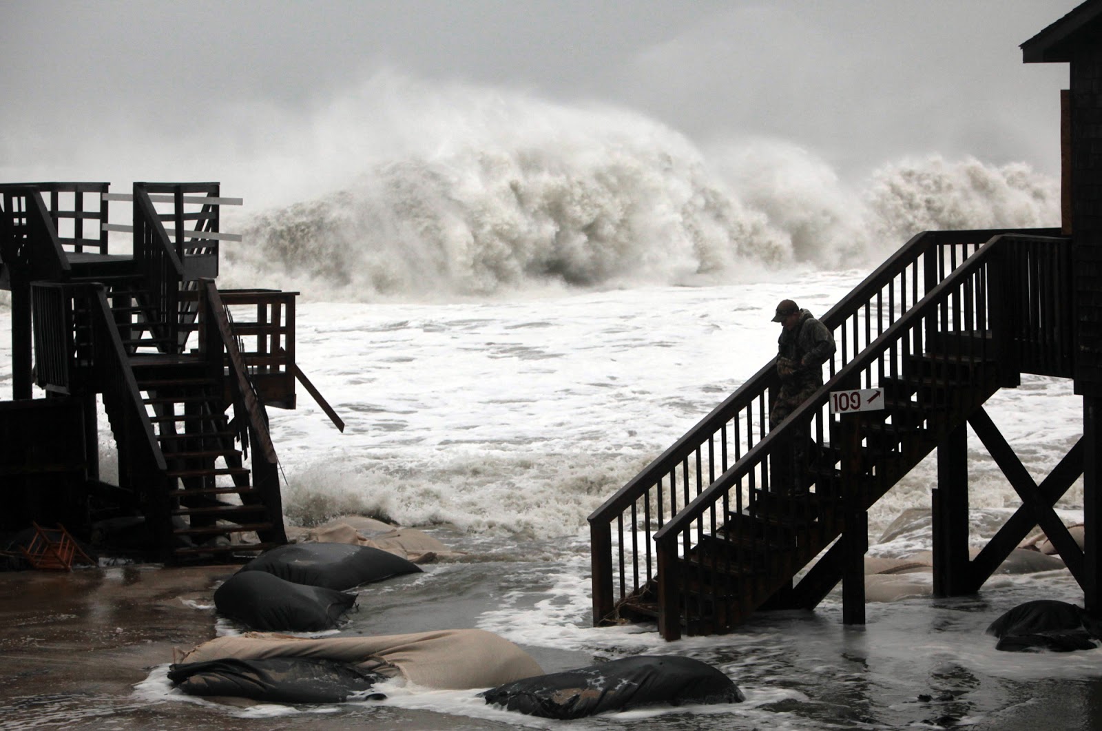
The Indian River inlet has massive stone jetties and a fierce current.  I have seen 60-foot boats tossed around in the inlet like potato chips so I was leery of making the passage.  -Washington Tuttle


I wake at 6:15 to a steady NW breeze.  A front had come through overnight, the rain is gone and it is a clear morning.  Bruce gets up and we stow the boom tent and sleeping gear.  We have time to kill.  Spartina is packed and ready to go, but high tide is not until 8:39.  We want to wait for the tide to quit running before going through the inlet.


We listen to the weather radio - 10 to 15 knot NW wind for most of the day - perfect for sailing south to Ocean City on the ocean.  Bruce and I talk about our plans, what to expect on the ocean, the option of turning back to Indian River Inlet if it is too rough or the wind fails.  And we talk about the point of no return, where with time and tide we just keep going to Ocean City Inlet regardless of what happens.  I check the nav lights which are in place on the bow sprit and the boomkin should we get caught outside overnight.


Anchor up at 7:40 we motor around an island towards the inlet.  I am worried about running out of fuel as we enter the channel so I get Bruce to pass back the fuel can and check the outboard, which I had already checked at anchor.  The tank is full.  Fishing boats speed by us on the way to the inlet.

Just after 8:00, sooner than I planned but I was anxious to get going, we enter the channel to the inlet.  I hope the tide would have slowed by now, but it has not.  The water boils in the inlet, my timing is bad.  It is choppy up ahead to the right, there is an huge eddy swirling to the left.  I throttle up to where we should be making four knots or more, we are making two or less.  Spartina slips and slides across the stream.  I look to a flag flying on a tall pole just north of the inlet, it is standing stiff in the wind.  The flag is at the coast guard station and I look down to their small boat docks to see three men in their dark blue coast guard uniforms, one of them is pointing at us.  We bounce through the angry chop.  Behind Spartina are waves rolling up to our stern and breaking, the waves going in the opposite direction of the running tide.  Three offshore fishing boats are racing through the inlet throwing up big wakes.  Two look like they will pass to the starboard and the other one to our port.  I try to keep a steady course, let them adjust their course to us.  The boats pass us as we near the end of the rock jetties, their wakes adding to the roiling water.  One fishing boat gets past the end of the jetty and makes a hard right turn, telling me there is deep water just beyond the end of the jetty.  The tide is still running but the water is calmer near the ocean.  We reach the end of the jetty, I pull the tiller to port.  We round the south jetty and are out of the inlet.  The water calms down immediately and it is quiet, a beautiful day.  There is a white sandy beach a few hundred yards to the west.  I look at the clock and see that it took 20 minutes to get through the half mile long inlet.  Only 20 minutes, but a long 20 minutes.

We raise the mizzen and Spartina points into the NW wind.   With a surprisingly crisp wind I tuck in both reefs and begin to raise the main.   An orange coast guard patrol boat coming out of the jetty behind us.  With a sick feeling in my stomach I remember the one guy pointing at us in the channel, wonder if they are coming to tell us we don't belong on the ocean.  I look down and focus on cleating the throat and peak halyards of the main.  I don't want to look up, I don't want to see the orange boat heading our way.  I wonder if my flares are in date, they'll ask us if they come over to Spartina.  Keeping my head down I ask Bruce to look around and see if an orange boat is approaching us.  Long pause, then he says "no."  I look up and see the coast guard boat heading north, away from us.  The jib is raised and we are sailing on the ocean.

We sail south off the beach at over four knots.  The water is calmer than I expected and the wind is steady.  With Bruce at tiller I shake out the first reef and then the second reef

We can see people walking along the shore in Bethany Beach.  On the dunes a man stands next to a woman pointing at Spartina.  I wonder what we look like from the beach.  The sand, the surf, a little open water, and three sails of a small boat.  And beyond that the wide open ocean.  I smile.


Dolphins are everywhere.  They come in close to Spartina, closer than ever before.  It is a relaxing, peaceful sail.  We follow the curve of the coast, staying a few hundred yards out beyond the breakers where the water is smooth. The sun peeks through the clouds.


From Bethany Beach we can already see the tall buildings of Ocean City.  In between the two towns on the beach are fisherman, their four wheel drive trucks parked nearby and the long surf casting rods in holders stuck in the sand.  Some sit in chairs, others stand at the edge of the surf.  I look at a fisherman with my binoculars to see that he is looking at us with his binoculars.


I breathe a sigh of relief as we approach Ocean City.  Bruce asks about something that looks like poles sticking up on the beach at a sandy point.  Looking with the glasses I see they are people, vacationers walking on the dunes.

The cloud cover moves in and I wish it was a few degrees warmer.  The wind varies and our speed goes back and forth between 3.8 knots and 5 knots.  The clicker on the trolling reel goes off.  I reel in a blue fish that is hardly bigger than the lure, our first fish after trolling up Chesapeake Bay, down Delaware Bay and now down the coast.  I think we should have done better than that by now.  I unhook the blue fish and throw it back.


Just off the Ocean City tourist strip the wind falters and we are becalmed.  A school of dolphin swims near us.  A large powerful boat heads our way, a dolphin watching boat with just a few off-season tourists aboard.  They curve around Spartina and we roll in their wake.  They want to see our school of dolphin.

Bothered by the rumbling engines the dolphin leave and the boat gives chase, and then the wind returns.  This new wind, lighter than what we had before, is now out of the west.  It carries us south along beach with a classic old the boardwalk.


As Bruce photographs the ferris wheel at the old amusement park we realize that the park marks the end of the beach, the jetty to Ocean City inlet is right next to it.  It is not yet 1 p.m., we are here hours earlier than I had imaged.  I briefly consider trying to sail through the inlet, but realize with a west wind it is probably not a good idea.  We drop the sails and start the outboard.  Passing a channel marker we turn in towards the inlet and Spartina begin to slide backwards.  I throttle up the outboard, we still slip away from the inlet.  Throttling up even more and the best we can do is hold Spartina's position in the outgoing tidal current.  Thinking back to the tides I realize I had planned on riding a flood tide into through the inlet, but that plan was based on reaching Ocean City at 3:00 or 4:00 in the afternoon.  We'll have to wait.


We motor across the current, round the south jetty and drop anchor in 10 feet of calm water.  I settle back in the aft cockpit and close my eyes for a moment.

"Steve....Steve.....Steve"I hear my name being called but can't figure out who is shouting.  I realize it it Bruce and then, with a start, remember we are on a boat near a jetty.  I jump up and look around.  Spartina is fine.  Bruce was shouting just to wake me from a deep, deep sleep.  "It's been an hour and a half" Bruce says, the tide should be slack.

Bruce is right with the time and tide, but the tide isn't on schedule.  We motor back into the inlet and I'm surprised at how fast the water is running out.  I throttle up and we make some forward progress.  I throttle up more, watching the people standing on the jetty and marking the forward progress  by matching them against the ferris wheel in the background.  I glance down at the gps to see we are making less than a knot when, with the outboard running at this speed, we should have been making four or more knots.  The currents, an hour after what should have been low tied, is still running at three knots better.

I watch the gps and see that the farther we get into the inlet, the better our speed.  A knot, then two knots, then close to three.  And we are through the inlet.  We motor into the harbor and to top off our fuel tank.  I ask the woman at the fuel dock about the tide running so late.  "Yeah, it does that sometimes."

We motor to a bait shop where I pick up a couple of bottles of iced tea, then turn south and raise full sail on narrow Sinepuxent Bay.  The mainland is to starboard lined with some upscale homes, Assateague Island with her beautiful wild horses is to port.


The afternoon wind comes and goes, we sail for a while then motor, then sail some more.  It is beautiful and peaceful.  The charts show very shallow water to the east and we cling to the channel markers.  Bruce is looking along shore hoping for a restaurant, but all we see further down the bay are woods and marshes with a couple of campgrounds.  Motor homes fill the campgrounds, the smoke from barbacue grills making us hungry.

In the evening the wind fails and we motor past two more channel markers, turn east towards Assateauge Island and drop the anchor in about six feet of water.

Dinner, then clean up the boat.  We are tired, we are relieved.  We've made it down Delaware Bay, through two inlets and an ocean sail.  Does it get easier from here?

steve

distance traveled             28 nm

moving average                2.9 knots

moving time                     9 hours 38 minutes 

Monday, October 15, 2012

day five - mystery bridge, south to Indian River

In the morning the small drawbridge opened.  I motored through into the beautiful canal to Rehoboth Bay.  There was another drawbridge further down the canal for a road leading into Rehoboth.  The bridge tender was delighted to see me.  Not many sailboats come through the canal.  - Washington Tuttle


I get up just after daylight for an early morning walk through Lewes.  The weather is calm and clear, no sign of the rain and wind that had been forecast.  I walk back to the town dock to see a large catamaran coming down the canal.  I slide Spartina up the dock a ways to make room for them, then help them tie up.  I ask about the bad weather, they tell me it had slid north of us during the night.


Soon Bruce is up and we are stowing the boom tent as Marty, the dock manager, comes by to say hello.  "You guys didn't sleep on that boat did you?" he asks and we smile and start to say "yes we did" until we see a frown and quickly say "no we didn't", hoping not to have violated too many local ordinances.  Marty asks about the trip and we tell him our plans, tell him we've got a bridge opening scheduled for 10 a.m.  "What about the other bridge?" he asks.  Caught off guard, I sheepishly admit I had missed the other bridge in my planning.  "You need 24 hours noticed to get through that one" Marty says.


"How tall is that bridge? I ask.  "Oh, you can probably get through" Marty says while looking up the masts, "or maybe not, I don't know."  "How far away is the next bridge?".  "Not too sure about that, not many people go up that way" Marty says.


I call the bridge number, which is the Delaware Department of Transportation, to confirm our 10 a.m. lift.  A woman confirms the lift, then says the bridge tender wants to know if we need a lift at the Rehoboth Bridge too.  "Well, that depends on the bridge clearance" I say, "how high is it?"  She doesn't know.  "Can you ask the bridge tender?"  She calls back to tell me nobody knows how high the Rehoboth Bridge is, but regardless a tender wants to be there when we pass through.

As I ponder the fact that nobody but nobody - including the bridge tender - knows the height of the next bridge, the woman asks me what time we'll be passing through there.  I'm at a loss at this point as I'm not sure how far away the bridge is, plus we've been told that the canal is very shallow and muddy and the current can run several knots.  I tell the woman I really don't know when we'll be there.  "How about 3 p.m." she says, "can you make it then?"  Yes, I think we can.

We motor north on the canal, away from the Lewes Bridge, to top off the fuel can at a marina.  We ask at the marina about the mystery bridge and get the same response.  Not sure how far away it is, not sure how high it is.  Might get through there with that mast, might not.

We motor over to the town dock to await our bridge lift.  Marty the dockmaster rides up on bike and tells us we overpaid our dock fee, hands me a $20 bill.  Thanks very much, I say, this looks like lunch.  We cast off and the bridge begins the lift.


We pass under the bridge and quickly go from downtown Lewes to pure nature.  It is one of the most beautiful canals we have seen.  Pine trees to the west, a huge expanse of marshland to the east.  Herons, cormorants and ducks.  Wildflowers and marsh grasses.


We pass down the canal at idle power, happy to find that the warnings of shallow water and fast currents were far from accurate.  The current is gentle, the water deep.  After two days on the Delaware Bay it was a change of pace that we both welcome.  We take turns at the tiller, take turns with the camera as we enjoy a peaceful fall day.


Forty-five minutes down the canal we start to see homes along the shore line.  The canal curves and we see the mystery bridge to Rehoboth, the clearance marked right there on the side plain as day at 16 feet.  Spartina's mainmast is 18 feet tall.  It is not yet 11 a.m., we've got over four hours to wait for our lift.  I look around for someplace to tie up to while we wait.  Looking at an old broken down dock I hear Bruce is saying "Do you hear bells ringing?"  It is the bridge, and the bridge is opening.  The bridge tender, probably the same one who let us through at Lewes, is letting us through the Rehoboth Bridge.  They waved the 24 hour rule, and saved us hours by ignoring the 3 p.m. lift.  "Thanks very much" I say over the radio as Bruce and I both wave to the tender.


Thirty minutes later we motor out of the canal jetties into Rehoboth Bay with a nice SW wind blowing. Full sail up we turn east to Dewey Beach.  Sailing just off the resort (read "spring break party") town  we see people walking into a waterfront restaurant.  We tie up on a long, empty pier and have a great lunch of excellent burgers and fries, eating just a table or two away from Elvis (at at least one of his impersonators).

Back on the water with a stiff breeze we sail south towards Indian River Inlet.  I pick out a possible anchorage and try to sail directly to it past some shoals.  Soon the centerboard clanging on oyster reefs.  We bump over one shoal, then another.  The tide is on the way out and the shallows are getting shallower.  Seeing that we are not getting anywhere, Bruce, sits up forward with the binoculars and gps, points out some markers to the west.  I'm hot and tired and frustrated by the shoals.  We fall off and head that way, bumping over two more shoals along the way with both the cb and rudder raised.  We make it to the channel where we drop the sails and start the outboard.  The water is shallow and the current is running.  A red buoy sits up on top of an exposed sand bar.


The channel leads us around a marshy island to the Indian River and our first quick look at the inlet.    We motor back north then east and work our way through the sandbars to the area I had originally picked out for our anchorage.  It is a flood tide and the shoals are disappearing under the surge.  We drop anchor, then raise it again and move to another spot.  We decide this is a good spot, out of the way of the local boat traffic and plenty of room to swing at anchor with the changing tides.
At dusk we listen to the weather forecast and watch the lights glow at the bridge over Indian River Inlet, the bridge we hope to pass under the next day.  Bruce finds a baseball game on the radio, I drift off to sleep.

steve


distance traveled             17.3 nm

moving average                3.0 knots

moving time                     5 hours 51 minutes