

Thursday, July 31, 2014
inlets, shallow water and trail mix

Summer, a very pleasant one at that, is moving along quicker than expected. Just about five weeks before the next sail. I've started looking at charts, waypoints and google earth. If the wind is right for sailing the seaside of eastern shore, it will make for some interesting navigation. Above is a photograph I shot out of a not-too-clean airplane window while flying back from Boston a couple of weeks ago. It shows Quinby Inlet, which is just south of Wachapreague Inlet, where I plan to come in off the ocean. The waterway is typical of the eastern shore - narrow winding channels. Beautiful, but also confusing when seen from water level. And all that open water at the bottom of the photograph, much of it is a foot or less deep.

I have most of my breakfasts (granola bars), lunches (tuna salad and crackers) and dinners (freeze-dried camp meals) in hand. When at the store these days I grab a little something extra, in this case, raw almonds and pumpkin seeds, for the home-made trail mix.
I need to start sorting through the batteries, rechargeable and otherwise, update the SPOT message and do a ton of other little things to be ready.
Tuesday, July 29, 2014
thirty five years ago
August, 1979

"For most of the morning we glided from point to point along Vavau's scalloped western coast before a light northerly. At 11:00 we were able to turn the corner and see for the first time into the midst of the group, at which point began a game that was to continue for my entire stay in Tonga: What island is that? More than once I thought I had everything sorted out, only to be confused when more islands came into view a quarter mile farther on."

"The sailing was delightful. No, more than delightful. Marvelous. Chidiock has proven herself at sea, but here, as I played the wind shifts off each cliff and point, gentle wavelets lapped at the hull, and "the ordeal" of an open boat circumnavigation became a pure joy."
-Webb Chiles, THE OPEN BOAT: Across the Pacific

Webb's path aboard GANNET, from Samoa to Tonga, will be through the same waters and islands that he sailed in 1979 on Chidiock Tichborne, his 18' yawl.
The chart will be digital this time, the photographs in color.
I hope the sailing will be just as marvelous.
Monday, July 28, 2014
ebb and flow
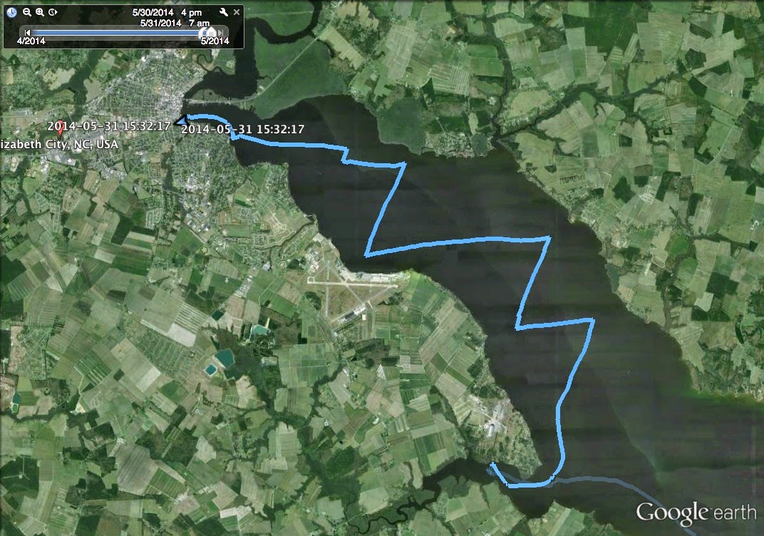
I chose my dates for the fall cruise based on work and family schedules, yet I was very pleased to find today that the starting date has tides that would make feasible another attempt to sail down the seaside of the Eastern Shore, round Cape Charles and complete my circumnavigation of the Delmarva Peninsula. High tide is predawn and we could catch the ebb tide out of Chincoteague Inlet. Low tide is late morning, allowing Spartina to come in with the flood tide 26 miles to the south through Wachapreague Inlet. Perfect!

So the tides are just right. The other factor will be the wind. I'll need wind somewhere out of the WNW to NNE quadrant. Any other direction would make the passage difficult, particularly since there are no other navigable inlets between Chincoteague and Wachapreague Inlets. We'll have to hope for the best.
My first choice, completing the circumnavigation, is marked in red above. The backup plan, if the wind doesn't cooperate, is marked in yellow - quite simply a nice sail from Onancock through Tangier Sound, up the Honga River, then north to Tilghman Island and maybe St. Michaels, then back by whatever way seems interesting. I've done versions of that sail before and all I can say is that I very much enjoy those waters.
We're about five weeks out, time to start checking food, batteries, etc.
Sunday, July 27, 2014
more from the GoPro

A few more photographs from the GoPro, shot yesterday and today on the Elizabeth River.

I find I like the images best where I have the camera mounted level to get a flat horizon and, for most part, vertical lines. The very top frame, while rigging the main mast, the camera it tilted up and the horizon has an inverted curve. The image just abve, the camera is tilted slightly down, resulting in a curved horizon. And the photograph below, the camera is level, the horizon straight and the flag pole is vertical. That's just about right, I think.

The "auto" white balance setting works best in full sun, but there is enough information in the files that contrast and color balance can be tweaked in PhotoShop to get decent results, as in below.

Below is from this morning, with an overcast sky. Camera was mounted on the forward end of the boom looking aft. Not too bad on the distortion. With the mounting gear I can only mount directly in line with or perpendicular to the mounting surface, in this case the boom. I would have like to have angled the camera so that it was pointing directly aft, but I don't seem to have the hardware for that. The horizon is not bad (but could be better) and, if the camera were pointed directly aft I think I would have avoided the curved mizzen mast.

For a short while had the youngest daughter on board, home for a weekend visit from college. Sometimes I think the best thing about small boats is getting Dad and daughters to talk. Or in this case, getting Dads to talk while the daughter laughs at what they are saying.

Saturday, July 26, 2014
the swan

My friend Bob sent me this photo of a swan, as he describes it, as I was backing away from the dock after dropping him and his wife off after a nice sail on the Elizabeth River.

It was our typical summer weather - hot wind out of the southwest - as they joined me for a couple of hours, plus I did a few hours by myself testing out the GoPro camera. Not thrilled with the amount of curve in the photo above, but I was happy with that nice breeze. I will post some more photographs from the camera in the next day or so. Overall, I like it. It's a tool and it will come in useful at times.
Friday, July 25, 2014
schooner for sale

The schooner Virginia, the iconic tall ship with the sleek black hull, is for sale. This is very sad news to me. The economy has not been kind to the replica pilot schooner, which was launched in 2004.

In 2009 the tall ship first ran into financial difficulties. At the time Virginia was spending time sailing in the northeast and down in the Caribbean, and probably not enough time in local waters. She was brought back on short notice and sat on the waterfront for a couple of years.

Recently the Virginia re-emerged with a new business model, spending much more time around Norfolk, Portsmouth and ports on Chesapeake Bay. She tied up with all her flags flying for local festivals, took school children out for sails, opened for tours and worked to become part of the community. But still, operating costs exceeded income.

I've been a guest on board the schooner several times over the years, sometimes for day sails, sometimes for the Great Chesapeake Bay Schooner Race. The captains and crew have always treated me very well.

Just sailing near the schooner on the Elizabeth River waterfront has been a joy. Friendly waves and well wishes from the crew always make a day on the water seem just a little bit nicer.

They have even given me a bunk to sleep on in Chestertown during the Sultana Downrigging Festival. Because I live in Virginia and the schooner is named Virginia, festival organizer Drew McMullen referred to the sleeping arrangement as a "berth right."

According to news reports, the ship costs about a million dollars a year to operate and the organization is a million dollars in debt. They think the ship is worth two million dollars, but it is the market that will determine what the ship is worth.

The economy has been rough for tall ships in general. The Spirit of South Carolina, built a few years ago for four million dollars, was recently sold to a private owner for less than a half million dollars. I don't know how many people, organizations or foundations will be interested in a 126 foot long wooden ship that needs a well-trained crew and constant maintenance.

I do hope she finds a buyer. It would be nice if the schooner stayed in our area, or at least on Chesapeake Bay. The Great Chesapeake Bay Schooner Race will not be the same without her.

The Virginia is in Rhode Island right now, she'll be back home by mid-August. I hope to sail with her on the waterfront then, but I know now that it will be a bittersweet time on the water.

Wednesday, July 23, 2014
ports, passages and paying attention (or not)
I received a question from Lorenzo about access to storage spaces on Pathfinders, particularly through the ports beneath the seats in the aft cockpit. I will give a little rundown of what I store and where. The simple answer to the questions about access to the lockers - it's easy to access to just about all the storage areas.

In the photo above you can see three access ports. There is an eight inch port beneath the pelican box where I keep a spare radio, spare gps and engine tool kit with spark plugs and shear pins. To starboard (we're looking aft, so to the left) is a six inch port where I keep emergency flares, chemical lights and plastic bags. Forward of that, where you cannot see, is another six inch port beneath the seat where I keep a watertight plastic jar with batteries, spare bits of line, spare hardware and a filet knife. To port (on the right) is a six inch port that has access to fishing tackle. Forward of that is another port opening to a locker with cleaning and toilet items - toilet paper, a roll of shop towels, etc. All lockers are easily accessed. While sitting on the seat I can reach down, twist of the port cover and reach inside to get what I need. The trick is to know what is where so there is not a lot of searching around.

Spartina has four eight inch ports, two on the thwart and two on the bunk flat, all of which you can see above. When cruising, food, some clothing and some gear are stowed in the thwart lockers. Beneath the bunk flat I keep eight gallons of water, a tool kit, spare anchor and chain - all heavy gear which sits next to the ballast, 30 lbs on either side of the cb, where it belongs.

There is one more port forward up under the foredeck in frame no. 1. When building the hull I put a large metal hook on the forward side of the bulkhead to starboard of the port thinking I could hang a coil of extra line there. I have never used it, the space - several cubic feet - is empty and serves as positive floatation if needed. To date I have never needed that positive floatation. I did install two small hooks on the aft side of the bulkhead where I hang a mesh bag. Two-gallon zip lock freezer bags fit perfectly in the mesh bag. It is there, out of sight, where I keep my trash - empty foil packets and cans from food, dirty shop towels, etc - while cruising, dropping off the trash at marinas/ ramps whenever I can.
I have been using the term "ports," but now that I go to the Beckson site I see they are really called deck access plate. I use the twist out models. The two on the thwart and the two on the bunk flat need to be the replaced this winter, the rings have developed cracks from being stepped on over the years. They have put up with a lot of wear and tear, I'm not surprised they are cracked. I will replace with the same model of deck plate.
------------------------------------------------

Webb is in Apia, Samoa after an interesting passage from Hawaii. Watching his yellow brick track, it appeared to be an excellent sail. Webb's passage log tells a different story. The earlier journal entry, which details some damage from a near knockdown, is an excellent read too.
---------------------------------------------------------------------
I was disappointed that it took me so long to put together the last cruise log. Work, family life and a small hurricane seemed to have gotten in the way. Looking back through the log just this morning I was pleased to remember a very nice sail. When writing the entries for the last couple of days of the cruise I was surprised to learn that what I had thought was an eight day trip was in fact a nine day sail. My mistake dates back to when I opened my notebook early on the morning of the eighth day to begin my daily notes and mistakenly wrote down "day 7," which I had already used the day before. It is easy to lose track of time out on a sail. I need to pay better attention. Or maybe not - losing track of time might be a good thing.

Monday, July 21, 2014
does green mean go? does on mean off?
I had planned to use yesterday as a GoPro camera test, mounting the camera with a new "wrist" mount which is perfectly suited to strapping the camera to mizzen and main masts, booms and gaffs. The idea was to set the camera to shoot one image per minute for as long as the battery lasted. I thought the battery charger had a green indicator light, meaning the battery was charged and ready to go. I set up the camera as I was rigging Spartina. Thirteen minutes later (and just 13 images) I hear a series of beeps indicating the camera was shutting down. The battery was dead. Maybe I misread the indicator light, maybe I installed the wrong battery. I am doing tests now and will have it figured out soon. This is the kind of problem I like to find well before a cruise.

The last few sails I've been having trouble with my Honday 2.3 hp four-stroke outboard. It would start up fine and I would motor down the river to where I raise sail. Later in the day, getting ready to head by to the ramp, I would have trouble starting the outboard. I would check the settings - choke, fuel "on" and gas cap vent "on." I would do the standard solution for a flooded outboard - wait five minutes and then attempt to start, again without luck. I checked the spark plug. The outboard would turn over, but seemed starved for fuel. Finally, even though I knew that there was plenty of gas in the tank, I would take off the gas cap to check the fuel supply. Then I would replace the cap and - what do you know - the engine would start right up.
After a series of tests, both on the water and in the garage yesterday, I realized that the on/off vent on the fuel cap was closed in both the off and on positions. Running the engine with the vent closed created a vacuum in the tank and, at a certain point, cut off off the fuel supply. How did this happen? I don't know. I'l take a look at the gas cap this week and see if I can repair it. I do know a new gas cap is $60.00.

Yesterday's sail was a delight. North wind, cool (relatively for this time of year) and dry, is unheard of in this area for mid July. No complaints here. The wind sock, below, blown to tatters by the passing of Hurricane Arthur, has indicated north and northeast winds for much of the summer. Typically we get strong southwest winds that bring hot, humid air our way. I will take that north wind for as long I can get it.
As for the battery and gas cap issues, I'm pleased to have identified the issues. Plenty of time - about six weeks - until the next cruise, and I'll resolve those issues well before then.

Saturday, July 19, 2014
day nine - welcoming wind

A light morning fog hangs over Newbegun Creek, dew drips off the sails. Cool air and a light N wind. A fisherman in a jon boat heads up the creek on the far shore, a great blue heron comes in to land in front of vine covered trees. We sail off anchor before 6:00.

Quiet sailing to Pool Point and the entrance to the Pasquotank. Weather radio mentions strong wind but we are in the shadow of tall trees. Patches of light fog drift across calm water. I decide to ignore the markers and slide over the shallows into the river at 6:30.
The wind, almost identical to the wind that pushed me downriver over a week earlier, is waiting for me. Spartina heels in the stiff breeze. We tack across the river and back, four knots or better. Cool, clear wind. Cottage Point in sight, a gust of wind and Spartina puts her port rail in the river. I smile until I hear an unexpected sliding sound to aft. I look back to see that my waterproof camera has slid across the day storage box, the pelican case and into the motor well, slipping down into the dark tea-stained water. Gone are the photos from the small craft advisory photos sailing back from Ocracoke, and the wet, windy sail up the channel on Roanoke Sound. I think about yelling out loud, but it is too nice a day. Shaking my head I look at the water behind, then look forward past the bow sprit.

The breeze feels warmer heading into the dock at Millie's. There's a fishing tournament going on for kids, they make room for me to tie up. Across the field I see Millie waiting for me. A quick bottle of water on her porch, then she follows me to the ramp where I leave my jeep and trailer, then back to Spartina to sail the last mile or so of the trip.

A little over 292 miles, sixty six hours of sailing, a long dreamt of visit to Ocracoke. A good trip, good to be back home.

closing in on Samoa

Webb Chiles is closing in on Apia, Samoa, the end of the second leg of his sail aboard Gannet. He appears to be making excellent time, his last yellow brick mark showing a speed of 5.7 knots on a course of 207°.

Straight line distance from his last mark to Samoa is about 160 miles. If the wind holds, and the wind from the earth wind map appears to be excellent, Webb could be in port in the next 24 to 36 hours, which would be slightly less than his prediction of a three week passage.
I don't know about you, but I'm having a great time following along on the sail. (The photo above is from Gannet off of San Diego last February.) As for my own sailing, tomorrow looks pretty good.

Thursday, July 17, 2014
an update from Aruba
Rik, my friend from Aruba, sent this photo of his Pathfinder to give me an update on the build. He has interior hull painting, rigging, outfitting and a trailer left to do, hopes to have her on the water in a month or two. Very nice job, don't you think?

And every good boat shop needs a dog, preferably one curled up on the floor.
Thanks, Rik, for the photo.
Wednesday, July 16, 2014
day eight - heading towards home
Under light grey skies I sleep in. Tucked back in the shallows of Peter Mashoes Creek Spartina rested comfortably all night. And so did I. Steady NE wind, we sail off anchor at 6:40 under mizzen, jib and yesterday's double reefed main. It is a quiet series of tacks into the wind and the incoming tide, centerboard raised about halfway as we work our way through the shallows and past the white sandy beaches.

Croatan Sound, then NW past Cahoon Point into Albemarle Sound at 8:00. Wind on the beam and we make over five knots through the fish traps and out into the open water.

Wind falls off, we round up and full sail by 8:30, 5.5 knots. Wind drops more and we are down to two or three knots as a crabber works pots to the NE. The sun peeks through the overcast.

Half way across Albemarle Sound the wind comes and goes. Under power, under sail, then power again. The wind fills in late morning, the huge blimp building on the Pasquotank River shows above the tree line. I'm surprised by a large motor vessel coming up from behind. Tuna salad, crackers and a cup of fruit for lunch. We enter the wide mouth of the Pasquotank just before noon, 5.5 knots.

Steady, relaxing sailing to Newbegun Creek on the south shore of the river. Confusing markers, at least to me. Maybe privately maintained, I try to follow them, but found myself outside the channel and work my way in slowly. A gazebo sits on a point to the west, a house and then farmland on the opposite shore. We sail in under winds blocked by tall trees, tacking back and forth looking for a nice anchorage. It is still early afternoon.

Finally, a place behind the trees, around the corner from the homes and peaceful in the afternoon light. Two fisherman in a jon boat work the tree stumps on the far side of the creek. Anchor down, I tilt my hat over my eyes and drift off to sleep.
at the end of a long driveway

Take the bay bridge tunnel, north on 13 up the eastern shore, miss the turn and go farther up to a place that has a name like it's a town but has only a gas station and a few houses, take the side road west and then south, backtracking until I find the right road, the number on the road changing twice where it doesn't match the map, then another road and another where I finally see an address, then back a long driveway, I'm talking a couple miles long, past a farm field and through the trees, past the "no trespassing sign" and into thicker woods where the pine needle-cover sand path winds more until finally there's the hint of a house around the corner. And beyond the house a creek and a pier.
It has been too long since I've been to the eastern shore.
Subscribe to:
Posts (Atom)


