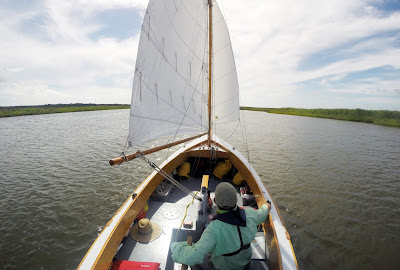
Awake at 5:30 after a clear calm night. Steady ENE wind. Sleeping gear stowed and sails raised just after 6:00 as two black skimmers glide across the water off the box. Low tide approaching and the water is less than two feet deep. I wait for the wind to push us back into the channel where I drop the rudder and center board. A pretty morning. We reach Barden Inlet at 6:30, the forecast time for low tide but I find we are working against a strong outgoing current.
In Barden's Inlet we bump into a shoal as the channel curves NE. We try to reach the next channel marker but against the current and sailing close to the wind we slide off to the side. Two more tacks and I think I'm getting closer until I look down at the gps and see we end up at the same spot each time. With the running tide we weren't going to make the channel. I look to the west and see deeper water. Maybe I can sail up that way and find an opening back into the channel. We sail comfortably a couple of hundred yards to where I think we can fall off and back into the channel. It looks good until we come to a shoal. Board and rudder up we slide up on the soft sand. I hop out, grab the bob stay and walk along the shoal looking just a little bit of deeper water. I don't find it. I walk Spartina back west and set the anchor in two feet and consider my options.
Standing on the deck I look west to see another shoal but beyond that there is the blue green of deeper water. As I watch a local boat heading south leaves the channel and runs rights through the water. Anchor up we sail NW past one shoal and up to another, then begin a series of tacks back east. We start to slide up on to the shallows so I hop out again and walk us clear. Back in Spartina we pick up some wind and with two more tacks we are back in the channel.
At 8:35 we pass Morgan Island with black skimmers lining the shore. Light cloud cover, five days into the trip and these are the first clouds I've seen. Marker 30 shows the tide running out two hours after the forecast low tide, the ENE wind is pushing the waters of Core Sound down through the inlet. At Marker 31 we bump into a shoal that is, according to both gps and the markers, in the middle of the channel. Green Marker 35 just after 9:00 and we head to Core Sound at 4.6 mh.
At 9:20 we bump into another shoal, this one in the channel too. Skies clearing and we follow the winding path up Core Sound. It's fun, easy sailing. The channel up the sound zigs and zags, opens up then narrows again. Late morning off the village of Davis I see a yellow object on the surface of the water. Up closer I see it is a sea turtle. Turning to grab my camera I look back to see the turtle is gone. Further up the sound I see a gill netter setting his nets and I wonder how the sea turtles do with the nets.

The wind is building in the early afternoon hours and we are sailing into a steep chop. It's a holiday weekend and looking across the sound I can see a row of bright umbrellas on the sand spit at Drum Inlet. I've given up on channel markers and the gps, the water is a light blue green and I can make out the shoals, plus local boats are running back and forth to Drum Inlet showing me the way.
We're off Atlantic at 2:30, 4.6 mh and choppy but for the first time all day we've got a wide channel and don't have to worry about shoals. At 3:30 we turn NW towards Thorofare Bay. There's a series of fish traps at Hall Point but I'm tired and decide to try a shortcut behind the poles and nets of the traps. I get closer and closer and think I see and opening, but about 20 years aways I see a line with small floats connecting all three traps. We quickly jibe and sail out around the traps. My time-saver cost me some time.
In Thorofare Bay with the wind and tide behind us we make 6.2 mh and sail to the bridge and the winding channel that carries us to the Thorofare. Rich green cord grass lines the narrow channel as we sail wing and wing. We turn NW heading to West Thorofare Bay, a pair of glossy ibis flying alongside the marsh.
Rounding Merkle Bay Point we sail NE to the far shore and find a small protected cove. Anchor down 5:30. Biscuit crumbles with sausage for dinner, excellent when dressed with a little olive oil and a dash of cajun sunshine. Listening to weather radio I hear that the edges of Tropical Storm Bonnie are approaching. I set up the boom tent for the night.


No comments:
Post a Comment