Thursday, September 30, 2010

Day Six - Tangier Sound all to myself

The weather forecast the night before was that same broken record. Small craft advisories, winds 20 knots with gusts to 25.....


And the forecast was accurate. Nearby Bishops Head was reporting sustained winds out of the south at 19 knots. The water outside Wheatley Point Cove looked pretty choppy. I thought about staying anchored for the morning, maybe read my book and relax, let the wind drop off a little. But a few minutes later I was tucking a double reef into the main, setting the jib and raising the anchor.
As I left the cove the wind seemed to fall off. I wondered if it was really dropping, or maybe I was just getting used to sailing in that kind of wind. Maybe a little of each.


I tacked back and forth on the Honga River. I felt like Spartina wasn't moving all that fast. Checked the gps to see I was doing 5.7 to 5.9 knots to the ESE. Up ahead I saw (I thought) green marker "5" in the distance, a straight run down the river. So I headed right towards it without bothering to confirm with my chart or the gps. The closer I got the more certain I was of the navigation. Trees to the right were the western shore, trees to the left were the eastern shore, marker right in between on open water. Until I got closer and the marker wasn't on open water, it was in a marsh. And then the marker wasn't a marker, it was a deer stand in a field. Thinking I was sailing downriver I had sailed into Lakes Cove.
So I tacked back west, kicking myself for the bad navigating but at the same time noticing two eagles and an eaglet fishing in the cove. Yes, I made a mistake. But I really enjoyed watching the eagles. Sometimes mistakes have little rewards.


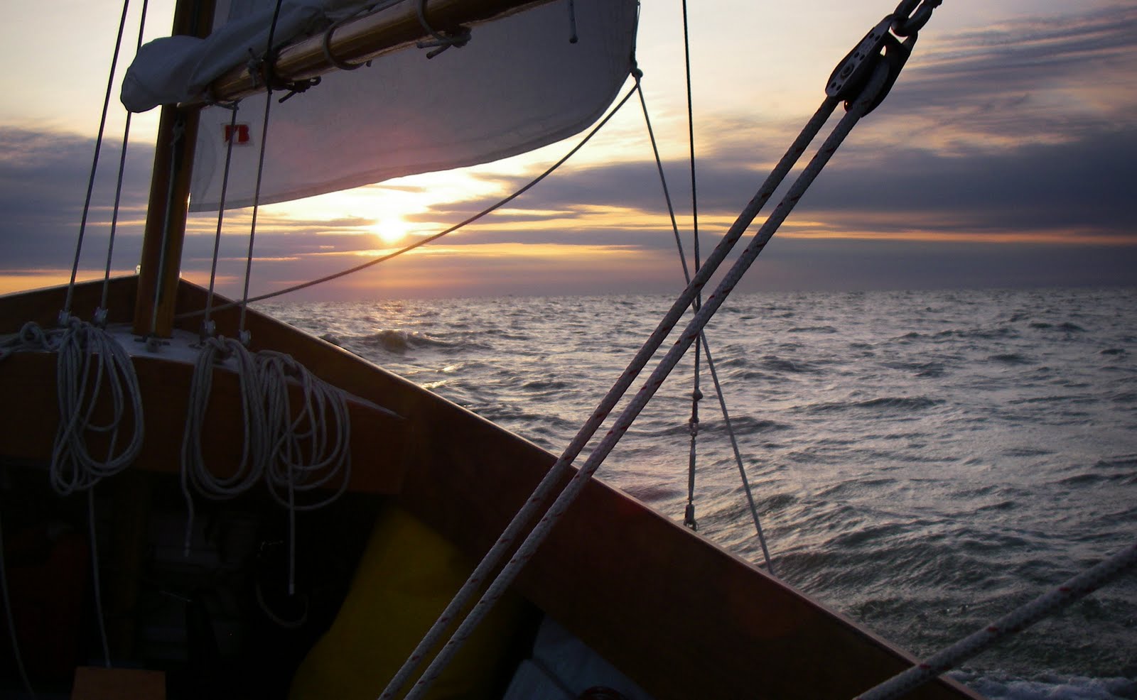
So back out on the river I spotted the real marker and worked my way south, finally under full sail as the wind dropped on the approach to Hooper Strait.

I passed the top of Bloodsworth Island and began a series of tacks the width of Tangier Sound with Deal Island to the east and Bloodsworth to the west. It was early afternoon, all the waterman had headed back to the docks. A rough windy day midweek, there were no sport fisherman or pleasure boaters out there. I had the sound to myself.
I made five tacks back and forth across Tangier Sound under full sail, the wind strong and afternoon waves building out of the south. It was a great ride.


On the last tack from Deal Island, a port tack, I sailed directly for Pungers Cove on South Marsh Island. I sailed through the south end of the cove and up into the entrance to Little Pungers Creek. Dropped anchor inside the marsh at 4:15.


After almost nine hours out on the chop it felt good to be inside the protection of the marsh. I took off my harness/inflatable vest and hung my foul weather gear up to dry. Notice I had the bilge pump out there on the bunk flat, thought I would take on quite a bit of spray. But I never used it.


After dinner I sat in the cockpit and read. I was just getting to the exciting part of The Lost City of Z, A Tale of Deadly Obsession in the Amazon. I read until it was too dark to read. Great book.


Below is a photo of my surroundings that evening. What a pretty spot.


I had one more full day on the water to go, one more island to visit.

steve

distance sailed 33 nautical miles

ave speed 3.3 knots

max speed 11.3 knots (I don't believe that either, it was probably 7 knots or so)


Day Five - back to the Honga River


It got breezy overnight as the cool front blew itself out, yet there was nothing but a gentle breeze out of the east when I woke up at 6:30. Watched the eagles as I packed up my sleeping gear, pulled the anchor just after seven and started a downwind sail on the Little Choptank River.

It was a slow easy sail, moving at two or three knots. The wind picked up briefly then just as quickly dropped off. By the time I reached James Island I was moving along at less than two knots.

Another beautiful morning. Not a cloud in the sky and a cool, gentle breeze. I steered with just my knee on the tiller and just relaxed in warm sunshine.


As I passed Oyster Cove I saw more eagles flying above the tree line. I guess there have been eagles all along, I just never looked up to notice them.
Off of Punch Island Creek the wind failed and I started the outboard, motor sailing south towards The Marshes.


The southwest wind filled in just as I approached The Marshes, also marked on some charts as The Big Broads, north of Barren Island. I was working my way to Fishing Creek, the northern entrance to the Honga River. I kept tacking off the beach and then back in, looking for a gap to cut through the shoals. I never did find a gap, but that was ok by me. It was a beautiful area. White sandy beaches mixed with marshes, clear shallow water with schools of menhaden packed in tight balls just off the shore.


A waterman ran by in his skiff, slowing now and then to toss an eel pot - a cylinder-shaped mesh trap - over the side. He didn't seem to notice me, but after he was done working he sped by again giving me a nice smile and a wave.

I caught a couple of small bluefish off The Marshes, including this one that wasn't much larger than the lure. All went back into the water to be caught another day.

As I began to pick out the markers leading to Fishing Creek I realized that there were no short cuts, I would have to tack back off the beach towards the top of Barren Island and follow the marked channel through the flats all the way to the creek. I tacked back out and the wind picked up, gps showing that we were moving at 5 knots. I followed the channel in with the wind on the starboard quarter, then made a turn to the left as the channel got narrower. The markers were now supplemented by sticks and pipes here and there showing the shoals both in and out of the channel. For the final run under the bridge I had the wind on the starboard beam, but it was a gentler wind blocked by trees on the shore. Looking at the water around the markers I saw I was sailing against an outgoing tide. As I passed under a bridge Spartina came to a stop, tide pushing out and wind blocked by the pilings. I cranked up the outboard to move about 20 yards to the past the bridge, caught the wind and kept on sailing.

The afternoon wind kicked up on the Honga River. I tacked southwest towards Wheatley Point Cove, dropped the anchor in the cove, surrounded by marsh and what looked to be a hunting lodge, at 4:30.

steve

distance sailed 25 nautical miles

ave speed 3.2 knots

Wednesday, September 29, 2010

Day Four - mizzen and jib to Oxford


The evening before the weather forecast was for a small craft advisory (again). Four days into the trip and three of them had weather advisories. I don't remember the specifics of the forecast, just a lot of 20 knot winds, gusts to 25. That kind of thing.


It was the sound of a small outboard that woke me up that morning. Two guys in a skiff running a trotline for crabs in Steve's Cove. They apologized for waking me up, the shallow cove was the only place they could find calm water on a windy morning.
I packed up the sleeping gear, had a quick breakfast of a granola bar and a fruit cup, then sailed off anchor under mizzen and jib.

Spartina was doing 6.6 knots under just the two small sails as we left Broad Creek and entered the Choptank River. I followed the shoreline SSE to Benoni Point and the entrance to the Tred Avon River. So far I had been on a broad reach but now on the Tred Avon I had about a two mile run into the wind.
To me this is where sailing a John Welsford yawl is at its finest. Just mizzen and jib, sailing perfectly balanced close hauled into the wind. The boat was dry and comfortable, just as if sailing into a strong, gusty wind and plenty of chop was no big deal.
It took an hour and twenty minutes to make the two mile run, tacking from shore to shore, but it seemed to go by quickly. I got a nice little wind shift at marker "2" that let me sail right up to the entrance channel to Oxford Harbor.

With all the wind and the narrow harbor I decided to go in under power. I wasn't quite sure where I could tie up and expected to be looking around for a while. I ran down the harbor past a supply dock, a restaurant and a couple of high-end boat yards. The restaurant had some open dock space so I turned around and motored back to Schooner's Landing. The restaurant wasn't open yet so I ran inside to ask the manager if it was ok to leave Spartina tied up there for a while. It was one of awkward deals where he comes the door of the restaurant, looks outside and says "Where's your boat?" and I say "Over there" and he looks and looks and can't see it and I finally have to say "Look down. No, down lower." He squints, sees it, laughs and says "You're fine."

I walked through the streets Oxford like a drunken sailor, my legs not quite ready for solid land after four days on the water. I seemed to weave back and forth on the sidewalks. I walked four or five blocks to the Oxford Convenience Market on Morris Street, a great little shop with just about anything you need there on the shelves. I got a cold tea, a gallon of water, some spray cleaner and some lotion for my dried out hands.
By the time I walked back to Schooner's they were open and I had a burger and iced tea while reading the paper. A very nice lunch.

An hour after tying up I was casting off, heading back out on the Tred Avon, this time for a nice down wind run. I started out under mizzen and jib, it was still blowing pretty good. This cutter below sailed over to say hello. A very nice conversation. Windy, sometimes hard to make out the words, but a nice visit with some friendly people.

Past Benoni Point and out on the Choptank again the wind seemed to drop off - or maybe I was just getting used to it - and I raised a double reefed main for a southwest run across the Choptank and out onto the Chesapeake Bay. Midway across the river I shook out a reef, leaving one in place.

At Cook Point I turned south and followed the shoreline of Trippe Bay. The wind was gradually easing all afternoon and I shook out the second reef. I put out the trolling line and got a couple of hits on the lure but lost the fish both times. Small bluefish I was thinking.

At Hills Point I turned southeast on the Little Choptank River toward my anchorage behind Ragged Island. The drag on my trolling line goes off and I brought in a decent sized bluefish for dinner.

About 4:30 I rounded Ragged Point and dropped the anchor in clear, shallow water behind a tall stand of pine trees. As I was dropping the main I glanced up to see a bald eagle fly overhead. And then there was a second eagle landing in a tree. And beside that was an eaglet, still covered in dark brown feathers. Wow. I watched them fly around the trees all afternoon, listened to them screech in the darkness after the sun had set.

steve

distance sailed 27.7 nautical miles

ave speed 3.4 knots

max speed 11.3 knots according to my gps, but I don't believe it (I suspect it was more like 7.5 or 8 knots early in the day)

daily logs

I'm posting the daily logs now. With the blog format they are in reverse order, last day posted at top and first day at the bottom. To make the logs easier to read I've listed them in the correct order on the ride side of the page under the Bay Days 220 track.

steve

Day Three - light winds, for a change


In the early morning hours the wind swung to the east. That wind, working against an incoming tide, made my anchorage a little bumpy for a while. A little uncomfortable as the boat rocked port and starboard, forward and aft. But I still got a decent night's sleep in.


All sails up and sailed off anchor at 6:45 as the sun came up. Light east wind. I sailed south to get around the sandbars at the south end of Barren Islands, then turned north a few hundred yards off of the shore. There is Barren Island below, I anchored down around the corner to the right.


After two days of small craft advisories I kind of enjoyed the light wind. The breeze just barely ruffled the water at first, carrying Spartina north at 2 kts or less. Ok by me, it was a very peaceful morning.
By 8:30 the wind failed completely, I started up the outboard and motor sailed (more motoring than sailing) past the upper end of Hoopers Island, Punch Island Creek (where Bruce and I anchored on a rainy night last year - you can read about it here and here) and Taylors Island.


Finally somewhere along the beach of Taylors Island south of Oyster Cove the wind kicked in. Not a lot of wind, but enough to carry Spartina along at 3 knots. A close look at the water rushing around a crab pot marker made me think the tide was helping move the boat along.


I sailed over the shoals and behind James Island onto the Little Choptank River just about noon. The wind picked up on the river and I sailed at 4 knots. Blue skies and a nice breeze, really great sailing. I passed this very nice yawl at the mouth of the Little Choptank and wondered by she didn't have her sails up.


The wind started dropping at 2:30 off of Trippe Bay. I started the outboard and motorsailed past Cook Pt. onto the Choptank River. It was time to start thinking about an anchorage for the night. Strong north winds were forecast for the next day so I wanted to be somewhere on the north side of the Choptank. I hoped that would give me a relatively easy sail to Oxford on day four.

After looking at the charts for a while I picked out a little cove just inside the entrance to Broad Creek. The charts showed a very shallow entrance with good protection for winds from just about any direction. I motorsailed across the Choptank and onto Broad Creek, entering the cove with a raised centerboard and rudder and dropping anchor at 4:45.

Our friend Mary Lou has since told me she thought I had picked the cove for its name. It is called Steve's Cove. Pretty cool. I had it all to myself, surrounded by farmland and tall trees. A very nice anchorage.

steve


distance sailed 28 nautical miles

moving average 3.3 knots

max speed 7.7 knots (that is from day two, max speed day three was probably 4 knots)

Tuesday, September 28, 2010

Day Two - the sound to the river to the bay


I was up just a little after 6, false dawn showing to the east. Small craft advisory (again), strong wind out of the north. I packed up the sleeping gear, raised the single-reefed main, mizzen and jib, sailed off anchor from Pungers Cove just as the sun came up.


I was sailing north into the wind and made a series of long tacks at around 4.5 kts from South Marsh Island to Deal Island, then back across Tangier Sound to the south end of Bloodsworth Island. One more tack out into the sound and then back to the the north end of Bloodsworth.
It was a rough day and a pretty good amount of spray came aboard. So much that when I heeled over the water up in the bunk flat reached almost to the top of the cook kit (on the starboard side) and light kit (port side). Just before 9 a.m. I hove to out in the sound and went forward to pump out the water. It always surprises me how peaceful it gets, even in rough water, when the boat is hove to. Sure, the flapping jib makes a lot of noise, but the boat itself becomes very calm. It took about five minutes to get the water out and then I was back sailing again.
The next tack carried me NW from the sound along the north shore of Bloodsworth Island and right into Hooper Strait. The wind seemed to fall off a little, the water calmed down and the sun felt warmer in the strait. Below cormorants take flight from the Hooper Strait Light.


As I entered the Honga River I looked back south to see the sun glistening off the water. It wasn't yet 10 o'clock and I was into the Honga River doing 5 knots up past Rippons Harbor. I shook the reef out the main and enjoyed a very pleasant sail. I knew I was in some very traditional water when I saw a marker saying "Hand Tonging Only", picturing the waterman hauling up oysters with only the 20 foot long tongs and a lot of muscle.


I followed the Honga River up around Smoke Point and made a couple of tacks to line myself up for a sail through the bridge that connects Hooper Island to Middle Hooper Island. I aimed for the opening of the bridge on a beam reach, knowing I had some room on either side of the channel as I had seen a few deadrises come in through the bridge and cut across what was marked on the chart as shallow water.


I passed under the bridge doing over five knots. Once beneath the spans the sails backed for a moment in the blocked wind but the momentum carried me through and the sails caught the wind on the far side of the bridge. Now that I was outside I had to pay attention to the channel, there was a shoal on the north side just a foot or two deep. I followed the markers out to deeper water on Chesapeake Bay.


One long tack out onto the Bay and one long tack back in brought me into Tar Bay, the shallows inside the Barren Island shoals. By this time it was mid-afternoon, a little too late to try and make Punch Island Creek. Barren Island would be my anchorage for the night.

I tacked inside, looking at a protected cove up behind the north end of the island. The water was getting shallower and shallower. Spartina's steel centerboard finally touched the bottom. But it wasn't the usual sound of the board going into sand or mud, it was the clanking sound of the board hitting an oyster reef. "Hey, oyster reef. I wonder if there are some stripers around" I thought just as the drag on my trolling rig started clicking.


I hove to in the shallows and reeled in a nice striper. With fresh seafood on board I decided to take the easy way out and sailed south into deeper water and a little cove at the lower end of the island.


And there's dinner. Thin slices of sweet potato, sweet red pepper, bits of garlic and fresh striper all cooked on the griddle.


That night was a spectacular night under the stars. All that wind was from a cold front that brought crisp, clear air down to the bay. I don't think I have ever seen the Milky Way to clear and bright. It was a pretty good day of sailing and a very nice night watching the stars.

steve

distance sailed 35.3 nautical miles

moving average 3.6 knots

max speed 7.7 knots

Monday, September 27, 2010

Day One - Rumbley to South Marsh Island


It was blowing strong enough for a small craft advisory, of course, as I drove across the marshes to Rumbley for the start of an eight day cruise. I would expect nothing less for a Chesapeake Bay sail.


The little Eastern Shore town about six miles north of Crisfield offered a very nice, free ramp that opened out onto Tangier Sound. It was 130 miles and a three hour drive, with a stop at Sting-Ray's in Cape Charles for breakfast, to the fishing village. I pulled into the parking area at 9 a.m. with a strong wind gusting out of the NNW.


The hardest part about rigging Spartina that morning was stepping the mast in the high winds. I have to stand the 18' mast vertically and lift it straight up, move it forward about 15 inches and then drop it down through the hole in the foredeck. The high winds, grabbing at the mast and all the lines, made this a challenge. I tried a couple of times, struggled, then waited about 30 minutes and during a lull in the breeze dropped the mast into place. (This was only the second time in six years of sailing Spartina that I have had this problem. Usually stepping the mast is easy, but high winds can be a killer. I'm considering cutting a slot into the foredeck this winter so I can set the mast at an angle and walk it into the vertical position. But I'll have to think about it for a while. I don't like to make any big changes on the boat without a lot of thought.)
Otherwise everything went fine. Got the boat rigged, pulled the jeep alongside and transferred all the gear, food and water for the trip.

I backed Spartina down the ramp just about 11 a.m. I was in no rush to get out on the water, the wind was forecast to drop midday and I wouldn't mind starting the trip in some more comfortable conditions. But the wind hung on so I pushed off from the dock under power at 11:20 and headed out the channel that leads to the mouth of the Manokin River and then to Tangier Sound.
I always plan the first day of any cruise to be an easy one. South Marsh Island was just about 12 miles away, an easy sail even if it was into the wind. I hoped to be there by mid-afternoon so I could get settled in the boat, have a good dinner and relax.
I started out sailing with just mizzen and jib doing a decent 4+knots. Once I got into a little deeper water the waves calmed down I raised the main with a single reef, sailing west towards South Marsh Island at 4.5 knots and better.


It was a beautiful, sunny day, not too hot. A great way to start the trip, with the added bonus of a forecast that called for the same kind of weather over the next several days.
By early afternoon the wind starting falling off as I approached the R"12" bell. A handful of boats were trolling the area, known as Chain Hole to fisherman, so I thought I would give it a try and put out my trolling rig. After a few passes I had no luck so I turned back west to South Marsh Island.


I reached the island just before 3:00 and spent about thirty minutes, with cb and rudder partially raised, exploring the east side of the island including the entrance to Little Pungers Creek.


At 3:30 I dropped the anchor in about three feet of water in Pungers Cove just north of the creek entrance. I had dinner (a single serving slice of spam, potato and chopped sweet onion, all cooked on the griddle) , set up the bivy for sleeping and then read for a while. A nice way to start the cruise. Below is my view of the world that evening.

steve


distance sailed 13 nautical miles
moving average 3.1 knots
max speed 6.4 knots

Saturday, September 25, 2010

velajador solitário

I received a nice comment today from Fernando Costa, a sailor of a very classic looking boat called "Morning Star" or, in Portuguese, "Estrela d'Alva". Fernando has a very nice blog and -though I don't understand Portuguese - he seems to have a special interest in velajador solitário - I think that translates to "single-handed sailor". In fact today he did a nice post about Spartina and the single-handed trip on Chesapeake Bay. Cool.


Fernando is from Cabo Frio, RJ, Brazil. Brazil will always have a special place in my heart ever since I was invited to join the crew of the Cisne Branco, the Brazilian Navy's tall ship, on a sail from Charleston, South Carolina to Norfolk, Virginia. I did a post about that trip here. That was one fun trip. I was welcomed aboard by every member of the crew, given the ship's uniform - blue shorts and a tee shirt - and considered a member of the crew. I will never forget the kindness shown to me by every sailor on board.
I won't forget the excitement of sailing a hundred miles off of Cape Hatteras with that huge spread of canvas, the great food, the traditions carried on by the crew (the captain would often begin explanations of what was going on with the phrase "this is a tradition that dates back 400 years...") or the experience of working in my cabin with the boat heeled over so far that the porthole was underwater and hearing high pitched squealing sounds. I went topsides to see that we were surrounded by hundreds of dolphin.


So I was thrilled to receive today's comment from a small boat sailor from Brazil. That is Morning Star below, a beautiful, very classic sailing canoe. I don't know much about Brazil, or the rest of the world for that matter, but I do know that Estrela d'Alva is boat with a lot of tradition and history. I would love to sail on a boat like that.


Frenando, thanks for taking the time to read this blog. That is a beautiful boat you have. Fair winds, and please keep in touch.

steve