Thursday, August 31, 2023

day twenty - the end


Windless and cool, under power Buckle Harbor 5:55.  Feel a very strong east to west current just outside the harbor.  A couple hundred yards more out in open water and feel no current at all.  Seems strange to me.


Near Johns Island I hear a clank of steel against granite, I've strayed inside of the lobster pot floats that mark, at least for me, navigable water.  I raise the centerboard, move out to deeper water, lower the centerboard.


 I am surprised that this is the first time it happens to me.  Should have been more aware.


6:55 in the distance I can see the boats in the mooring field at Atlantic Boat Company.  7:15 docked.

5.4 NM


day nineteen - a sail through the islands


Sail off anchor with a surprisingly solid west wind.  Brisk morning, not a cloud in the sky.  A couple of tacks to get out of the anchorage, cormorants with wings spread on one rock and seals basking in the sun on another.  


A prefect wind just to wind my way through the tiny islands between Deer Isle and Isle au Haut.  


Sail north pasta St. Helena Island to Green Island, then tack southwest past Potato and George Head Islands.


8:45 Harbor Island to port, 9:00 making 1.8.  9:45 less wind and doing just 1.4 alongside Nathan Island but who cares on a perfect day.  


Slip into shallow waters surrounded by Nathan, Pell, Burnt and Birch Islands, slipping out through a narrow cut east of Pell Island just before 10:00.  


11:00 Round Island to starboard, Wreck Island to port.  11:50 raise cb and rudder to slip over the shallows between Potato and Sprout Islands.  Maine sailing at its best.


Noon headed back towards Stonington, a hamburger for lunch sounds good.  I am reminded it is weekend as the harbor and dock are crowded with people out enjoying the water.  Have to wait about 15 minutes for some space to open up at the dock.  A quick burger then next door to the store to buy some bottles of iced tea.


Cast off and full sail at 2:05, strong west wind.  Downwind run to Buckle Harbor on the north side Swans Island.  Tuck in a single reef before passing between Enchanted and Saddleback Islands, 3.5 downwind.  3:20 Phoebe Island to starboard and after spending the morning sailing through island we are now on open water.  


4:15 Buckle Island in site and I watch sails disappear into trees a couple miles ahead.  Building wind and we turn with wind on the beam to enter the harbor.  Keep the mainsheet in hand with gusts while sailing through boats anchored in the harbor.


5:10 anchor down on the west side of the harbor.  Trees block the wind, the water is calm.  I set up the boom tent to get out of the sun, roll back the port side so I can enjoy the view.


Thinking about tomorrow's sail I check the weather.  Surprised to see a forecast with gusts to 40 and rain the day after next.  Maybe it is time to head back to the ramp.

21.57 NM


SAIL Magazine story, now online


 Wendy Mitman Clarke's wonderful story about SPARTINA is now online and can be found here.  There is even an audio version that can be found on the link.  How nice!  It was almost a year ago that Wendy joined me for a sail on the Corsica and Chester Rivers.  It was great fun to have her onboard.  

That beautiful photograph of SPARTINA was made by Kelli Mills as I sail out of the anchorage at Isle of Hope in Georgia last winter.

We've been getting the windy and wet remnants of Hurricane Idalia since late last night.  The storm seems to be sliding offshore now.

Two more days left for the sailing log from Maine.  The log should be complete by tomorrow morning.

day eighteen - fog, sun, wind and a nap


Wake to a morning covered in a thin layer of fog on Inner Seal Bay.  Everything a little damp from yesterday's weather.


No wind, under power 6:55.  Low tide and I follow the channel past the 10 or 12 boats anchored along the way.  No signs of life on the bigger boats.  Passing my first anchorage from yesterday, a cove surrounded by rocks just off of Winter Harbor, I realize I should have trusted my first instincts and stayed there.  A perfect anchorage for a small boat.


Out of the bay and passing Bluff Head I look to the east-southeast.  Isle Au Haut is hidden in fog.  7:40 I can see I can see small islands due east.  Merchant Island is somewhere beyond those small islands.  I turn towards the islands.  Soon they disappear in fog. 


8:15 a red buoy to port, nothing else but fog.  8:25 a low-lying island straight ahead.


Check the gps, can't see the islands on the screen.  I'm confused.  Switch to Navionics on my phone and get a better look.  Using the app I follow the path through the islands and ledges.  


Pass the first couple islands and a lobster boat comes into view.  A woman hauling pots on the boat pauses, smiles and waves.  Morning doesn't seem some damp and dreary any more.  The fog begins to lift.


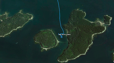
Sparrow Island to port, I can now match the islands to what I see on Navionics.  9:15 Harbor Island off the starboard bow, and next to that is Merchant Island.  Round small Harbor Island, drop the anchor in Merchant Harbor.  Waiting on wind, I spread out some gear to dry.  And then take a nap. 11:45 sun breaks through, getting warm. A little wind. Raise sail, tack out of the Harbor.  Wind disappears, drift in circles under full sail.  Check the app and gps, under power to Stonington at the south end of Deer Isle.  Pass several small islands, including Steve Island, then cut between George Head and St. Helena Islands.  Stonington ahead and I can pick out the town dock inside the mooring field.


Tie up at the town dock 1:50.  A sign warns strongly against overstaying the two hour limit.


I get a Caesar Salad at Stonecutters Kitchen.  Perfect light lunch.  


Then a walk through town.  During lunch I had read on my phone that it is National Oyster Week.  I search for oysters, stopping at a few restaurants and a food stand.  No luck.  It is getting hot so I step into the cool and comfortable 44 North for an iced tea.


Cast off 3:50 just as my time at the dock expires, but I don't think anyone would have minded if I stayed a bit longer.  Nice afternoon wind, full sail at 4:05.  Sail out toward Camp and Devil Islands, just enjoying the view and the wind.  


4:45 thunderstorm warning, heavy rain and high winds. I can see small, tight storm to the northwest.  The storm looks to be spent but figure it is a good time to head to an anchorage.


Anchor down in a little cove between Round and McGlathery Islands 5:25.

18.12 NM


Tuesday, August 29, 2023

day seventeen - a weather day


Wake at 5:30.  Rain.  Go back to sleep.  Up at 7:00.  Sweater, drysuit, hot chocolate to go along with breakfast.


Damp, cool and rainy.  Cell signal comes and goes.  I read, nap, catch up on the logbook.


Rain comes and goes.  In a well protected spot so don't feel any wind.


Heavy rains late morning.  Seven boats, mostly sailboat but also one trawler, anchored on the bay.


Checking my supplies I seem to have gone through most of the prepared breakfasts and lunches.  Break out the next batch and pack them for individual days.  Meat bars, Rx Bars and cans of tuna in each bag.


Rain seems to end early afternoon.  A catamaran raises anchor and leaves.  The cell signal suddenly gets better.  Skies grow lighter, temperature warms.  Late afternoon darker, colder.

Evening, rain, thunder, and some gusty wind.


Monday, August 28, 2023

day sixteen - south to Vinalhaven Island


I wake to a bright full moon and the sun rising over Islesboro.  Sail of anchor 5:45.  Reach the north end of Minot Island at 6:30.  Motoring south in the narrow windy channel between Islesboro and Minot Islands.  


Approaching Pendleton Point at the south end of Islesboro I spot the dock of a friend.  Her family has a home there.  Bad timing on my part, they won't be up there for a couple of weeks.  Maybe next year.


6:45 Pendleton Point, sailing.  Light breeze, blue skies to the south and a thin overcast to the north.  Had hoped to head to the west side of Vinalhaven Island but the light breeze is coming directly from there.  Fall off to the east and head for Oak Hill at the northernmost point of North Haven Island.


Making 2.2 at 8:00, 2.6 at 8:45 with Compass Island to port.  9:15 making 4.2 approaching Oak Hill.  


9:30 Burnt Island to starboard, Oak Island to port.  Full flood tide running, water rushing around the islands makes for a bouncy ride.  


A handful of tacks to work our way through Burnt Island the west and Dagger and Downfall Islands to the east.  


Past Dagger Island at 10:00, still confused water with multiple tide lioness water bunches up around the islands and ledges.  Finally calmer water south of Downfall Island.


See a small sail to the west and turn in that direction.  Meet Ed with his Chesapeake Light Craft Skerry STERNA.  A beautiful boat and he sails it very well.  We round up and exchange greetings,  it is always nice to meet a like-minded sailor.   After a few minutes we each go on our way.  I head south to Vinalhaven.  


11:00 turn southwest near (a different) Burnt Island, then south betwwitheen Stimpsons Island to starboard and Calderwood Island to Port.  Rough sailing against wind and tide in the rocky channel.  A few tacks, some up closer to the rocks than I would have liked, to make it through.  


Noon making 3.7 on Fox Island Thorofare on rough water.  Tack in close Calderwood Neck, 12:40 under power entering Winter Harbor.  Anchor down 12:55.  Put up the boom tent and enjoy a hot lunch.


As tide runs out in the afternoon I am not sure that I have picked the best anchorage.  Lots of rocks emerging late afternoon as the tide goes out.   Bad weather on the way and decide to find a better spot.

Anchor up and motor around to Inner Seal Bay on the south side of Penobscot Island.  Anchor down 5:00 with seven large sailboats already in the anchorage.

19.74 NM


Saturday, August 26, 2023

day fifteen - Islesboro


Calm but very chilly night, wish I had worn my thermal socks.  Cold, clear morning, dew covered boat.  Low tide, rocks exposed all along the shoreline.  6:00 under power.  A man on a 50' ketch waves me down, asks about the trip and wishes me well.  Tells me he and a friends had sailed off on a little open boats when they were teenagers.  Approaching the Castine town dock 6:20.  A voice calls out across the water, "Good morning, Steve."  I smile, it's nice to be known on the waterfront.  I tie up and run to the variety store for a sausage egg biscuits and a couple bottles of iced tea.


Cast off 6:50.  Leaving the harbor at Dice Head a light breeze fills in.   Raising sail I look after to see the arctic schooner BOWDOIN coming up from behind.  Waves from the crew as they motor by, SPARTINA making just a knot in the light air.


Beautiful morning.  Not going anywhere fast, just enjoying the breeze.  Islesboro straight ahead.  7:35 harbor porpoises, small and dark colored, swim all around the boat. 


8:40 making 1.9, more wind at 8:55 and doing 3.5.  Less wind at 9:45, making just a knot.


Motorsailing just after 10:00.  10:30 rounding Turtle Head at the north end of Islesboro, wind and sailing again.  


Navionics shows submerged rocks nearby.  Using the app much more than I had expected, keep it charged with the solar panel.


12:10 afternoon southwesterlies filling in north of Ram Island.  1:15 I look to the south and can see the car ferry heading from Lincolnville on the mainland to the ferry docks at Grindel Point on Islesboro.  Making 4.4.  1:25 Seal Island to the north, Flat Island to the south, tack back out onto West Penobscot Bay.


2:30 surprised to see the opening between Grindel Point and Warren Island.  I had thought there was one more point to round.  Sail up to Grindel Point, another tack tack and slip in between the islands at 2:45.

Excellent sailing south between Islesboro and Seven Hundred Acre Island in the afternoon winds.  Busy water with lobster boats and sailboats.  Anchor down Cradle Cove at 3:25.

22.59 NM