

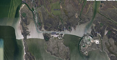
I've started making screen shots of satellite images of a few of the places I hope to visit on this next trip (I've exaggerated the color and contrast in these images so that the channels are easier to recognize). Below is the southern part of Smith Island with the town of Tylerton to the lower right. I would like to come in off the Chesapeake Bay side using Sheep Pen Gut at the left.
And here you can see the southern end of Middle Hooper Island and the tiny Lower Hooper Island separated by Thorofare Channel. I would like to end up anchored there around day five or six of the trip.

And below is South Marsh Island where I'll probably spend the first night of the trip. It is just about 10 or 12 miles from the ramp in Rumbley. You can see there are lots of tiny coves for protection from just about any wind.

I'll print these out and laminate them along with my other trip information. I'm also collecting tide predictions and sports schedules (there ought to be some good pennant races and nfl games going on in late September and I should be able to catch my share from sports radio is DC and Baltimore).
Bruce shot the photo of me at the top, motoring down the creek along the Ewell waterfront on Smith Island. After this hot summer it is hard for me to imagine it being cool enough to wear foul weather gear. But I guess it will cool down soon.
steve


No comments:
Post a Comment