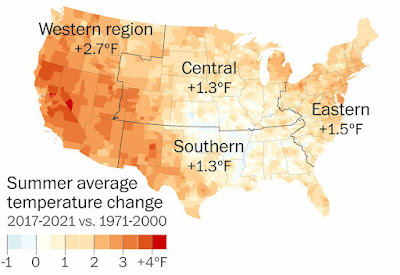
Since that infamous storm on June 29, 2012, a number of extreme heat-driven derechos have followed in its footsteps, breaking an array of records while leaving wide swaths of damage from Colorado to Canada.
In just the past six and a half months, two of the most destructive derechos on record have occurred. Both events blasted sections of the Midwest; the first on Dec. 15, 2021, and the second on May 12 of this year. Both events occurred on days with record-setting heat.
------
The only indication that any tropical weather might appear was the National Hurricane Center's notice Friday afternoon that a low pressure system had developed near Savannah, Georgia, and would likely bring some heavy rain in isolated areas over the weekend.
And yet, Tropical Storm Colin snuck onto the scene early Saturday morning, surprising the National Weather Service. How did this happen though? How was it possible for a tropical storm to spin up overnight with little warning?
Armstrong said Tropical Storm Colin was so weak that it stayed under the radar, literally, until the last minute.
"I can only assume the computer forecast models were unable to see the thunderstorm organization in time," Armstrong said.













No comments:
Post a Comment