Washington Tuttle's account of his Delmarva circumnavigation is less than clear when it comes to his path from Chincoteague South to Cape Charles. He left Tom's Cove at Chincoteague to sail outside on the ocean. The transcript of Tut's accounting says "I sailed all day. Late in the afternoon I found a small harbor. There was a Coast Guard Station on Anismas. I anchored across the creek a hundred yards from the ocean."
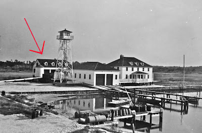
I cannot find anyplace on the Eastern Shore called Anismas. I suspect Tut told the interviewer that he anchored near a Coast Guard station on "an isthmus." But really it was not an isthmus, it was the tip of a narrow barrier island. And possibly the station was the old Parramore Beach Coast Guard Station, above, at Wachapreague Inlet. The Coast Guard chief told Tut that it was "six or seven miles" to town, which would be about the correct distance from Wachapreague Inlet to the town of Wachapreague.
From Anismas Tut sailed outside for another day, coming back in through an unidentified inlet to the fishing village of Oyster. From there he sailed inside the barrier islands to Cape Charles, the southern tip of the Delmarva Peninsula.
It was more work than I expected to place the waypoints for the second day down the eastern shore barrier islands. Regardless of which chart I used - Garmin Blue Chart, the printed Virginia Barrier Islands map or google earth - the channels were hard to follow. Sometimes there was not much of a distinction between channel, mudflat and marsh. Some channels meandered off into the marsh, then reappeared a short distance later. Some channels were lined with markers, some had no markers at all. It could be an interesting trip inside the islands.

Should we sail "outside" on day two, leaving out of Wachapreague Inlet, I see there are three inlets to get back inside the barrier islands. From north to south they are Quinby Inlet, Great Machipongo Inlet and Sand Shoal Inlet. You can see that there are two waypoints with skull and crossbones markers near Sand Shoal Inlet. These are waypoints marking shoals where there are breakers. After a closer look at the chart I see there are shoals outside of each of the inlets. I need to go back and mark those shallows too.
I plan on spending quite a bit more time looking at the Eastern Shore charts and google earth. Ideally I hope we follow Tut's general path - two days outside, the third day inside. We'll see. I do want to be familiar with the narrow channels, particularly up north, if we have to go inside.
While I had the gps connected to Garmin HomePort on my laptop I experimented with importing tracks of past cruises. Above you can see three of our sails -
The Crabhouse 150,
Back to the Islands and
Over the Top 200 - overlaid on the map of the Delmarva Peninsula.
There is not that much left to complete the circumnavigation.
steve


