

A cinnamon roll and iced tea at The Bean. Keith does a double take when he sees me on the porch, he quickly looks to the sea wall to see SPARTINA tied up there. "You're back!" I enjoy talking with Keith and the locals, wondering about the wind. The consensus is that the wind will be light or maybe non-existent. Cast off at 8:00 cast off, 8:05 sails up, 8:10 out past the jetty.

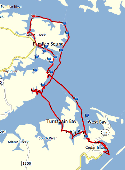
8:45 making 2.3 on a tack across the wide Neuse, hoping for a better angle on the light south wind. Jibe north, aiming for Long Point Shoal, and the wind fills in, 4.9.

9:15 making 4.1, steady, easy sailing. 9:45 using binoculars to look for the shoal marker. Clear skies and have the solar panel out to charge batteries. Sunshine lets me listen to some music via the phone and blue tooth speaker. How nice!

10:00 less wind, doing 2.0. 10:25 less wind, making 1.4, the day so pleasant I relax and enjoy. Get the first glimpse of the marker at Long Point Shoal.

11:25 passing the shoal marker, better wind, 3.3.

Past the shoal, with the white sandy beach of Swan Island to port, doing 3.7. Wind on the stern, sailing wing and winglet. A beautiful day. I look to the east and see nothing but the water of Pamlico Sound.

12:00 can see the water tower at Hobucken to the northwest, Maw Point off the port bow. Soon crossing the mouth of the Bay River at 3.5.

A few boats on the ICW heading up the river, pirates outside the channel checking their crab pots.
1:00 Rock Hole Bay to port, Sow Island Point ahead in the distance, 3.5. Light green water as we sail over the shallows just east of Bay Point. 1:25 turn to Sow Island Point for better angle on the building wind, 4.7. Cross the mouth of Jones Bay, pass Sow Island Point at 1:45, crossing over the shallows.

2:00 passing Middle Bay to port. I notice markers ahead through the shoals which surprises me. Years ago I sailed this area a lot and don't recall the markers at all. See a waterman coming from the northeast and he is tracking the markers so figure I should respect them too.
2:10 gps shows 5.6 as we follow the slightly curving channel. Passing Little Porpoise and Big Porpoise Bays at 5.5. Finally out of the shoals and jibe towards Mouse Harbor entrance at 2:30.
2:40 jibe towards Sound Point, sailing close-hauled into the building afternoon wind at 5.2.

A long port tack across Mouse Harbor carries us into Southward Bay and then Cedar Creek. Decide I want a little more room so jibe back out. Anchor down Cedar Creek at 3:10. Set up the boom tent to get some shade.

25.26 NM











No comments:
Post a Comment