
From the Baltimore Sun...
"Swollen by rainfall first from Hurricane Irene and then Tropical Storm Lee last week, the surging Susquehanna sent enough fresh water into the bay to completely replace all the water in it, according to Mark Trice of the Department of Natural Resources.
The USGS also estimated that the roiling Susquehanna scoured 4 million tons of sediment trapped behind Conowingo and other dams on the river and carried them downstream."
Chesapeake Bay does look like a mess right now. There is more to be concerned about than just a sailing trip. This could affect the bay for a long time to come. Sediment muddies the water, blocks the sunlight and inhibits the growth of subaquatic vegetation. Those seagrasses should be home for juvenile crabs, fish, etc. The nitrogen flowing into the bay in the form of runoff is a fertilizer that allows algae to grow, again reducing clarity and impacting the SAV's. Sediment, fresh water, algae blooms are all bad for the bay. Fish, oyster and crab populations could all suffer.
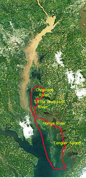
As for the trip, I'm following the news and will make a few phone calls before setting off on the cruise. I did find this satellite photo on the Maryland Department of Natural Resources web page. The visible runoff appears to reach the narrow stretch of the bay between Cove Point and the very upper part of Hoopers Island. I've marked my sailing area in red. The only overlap is, according to this photo, from Fishing Creek north to James Island at the mouth of the Little Choptank River. The runoff does not seem to be entering the Choptank Rivers. Hopefully it will stay out of Tangier Sound too. Maybe I'll adjust my plans and sail the Honga River, Tangier Sound and Pocomoke Sound down to Onancock. Thanks Kevin and Mary Lou for the updates, I appreciate the information.
steve


No comments:
Post a Comment