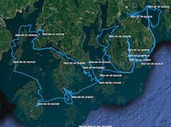
A bit rolly in the early morning hours as the wind swings to the west and wraps around Windmill Point and waves reach into Paul Cove. 7:15 raising sail as the sun crests the horizon.
Beautiful clear morning. Sailing south at 2.9. 7:50 out on the open water of the Honga River, 4.0 with lower Hooper Island to starboard. 8:20 Hooper Strait Light to starboard, Bishops Head to port, 5.3 with excellent wind.
8:45 across the strait, Bloodsworth Island to starboard, calmer water in the lee of the island, 4.8. Surprised to see there are no crab pots in the shallows along shore.
9:25 reach the south end of Bloodsworth Island with a rough crossing to South Marsh Island. Finally see deadrises working crab pots. Once in the lee of South Marsh Island, calmer water and making 5.4. 10:00 round up and tuck in a reef to make the crossing of Kedges Strait.
10:15 pick see Kedges Strait lighthouse. 10:25 in the strait, rough and choppy, doing 5.4.
10:40 approaching the shallows off the north end of Smith Island, fall off to the southeast around the shallows, calmer water in the lee. 11:15 easy sailing and 5.6 tracking down the east side of Smith Island.
Reach the south end of Smith Island 11:30, 5.0 and choppy now that we are on open water. Looking south I sort through the scene ahead of us. Once again I think I see Watts Island to the south but after checking gps realize it is Port Isobel, the heavily wooded island just to the east of Tangier Island. 12:10 tack into the calmer water behind the shoal that runs from Smith Island to Tangier Island.
12:30 tacking close-hauled towards Tangier. 1:30 calmer in the lee of Tangier Island. 2:00 tack off the eastern side of Port Isobel, then a series of tacks into Cod Harbor.
Pelican show me the floats of an oyster farm on the edge of Cod Harbor, stay well clear of them. A few more tacks up into the anchorage protected to the south and west by a sand spit. Anchor down south of Whale Point at 3:40.
I wake feeling as if I had slept in. Check my watch hanging back near the mizzen mast, it is just 6 a.m. I remembered waking in the night to a sky full of stars, then waking again to clouds, wind and chop. The clouds still hang low this morning, a hint of light on the eastern horizon.
I sail off anchor under mizzen and jib. The wind is out of the E at 15 with gusts over 20 according to the report from the nearby Bishops Head weather station. My course is due west across the Honga River to the Thorofare between Middle and Lower Hooper Islands. Leaving Crab Point Cove I sail comfortably with following waves. I find myself wondering if the low, dark clouds make the wind seem stronger.
The entrance to the Thorofare is hard to find. The channel runs north-south and as I approach from the east it is hidden by the marshy point on the south side. What I take to be two local navigation markers slightly to the north turn out to be duck blinds. I am heading for them as my gps finally tells me that entrance is to the left. I am almost in the channel before I recognize it.
It is a beautiful passage, first through a narrow channel and then over wide sand flats. That water is light green and very clear, the wind perfect to carry us under the two small sails between the islands. A green plastic chair sits on an islet looking towards the bay. I envy whoever gets a chance to use the chair and enjoy the view. My centerboard touches the bottom and I raise it, then it touches again and I raise it more. The rudder starts to drag in the sand so I swing that up. But I don't need the board or the rudder to tell me how shallow it is, I can look over the side and see.
The water gets shallower, the board is now up all the way, the rudder down just low enough to Spartina direction. I can feel the hull sliding over the sand and wonder if I will have to get out and walk the boat across the flats. Then the sand falls away and we sail out through the mouth into Chesapeake Bay. I round up and drop the anchor on the edge of a sandy beach to reset the cb and the rudder. I also tie a reef into the main.
Delighted with having sailed through the Thorofare, something I have wanted to do for a few years, I raise anchor and sail south in the lee of Lower Hooper Island under mizzen, jib and the single-reefed main. The wind is strong out of the E, the water calm in the lee of the island.
As the shore of Lower Hooper Island falls away to the east we get the wind and the waves funneling through Hooper Strait. It is rough, with waves in series of three coming from the SE. The first two waves in each set we handle fine, the timing of the third waves comes with the bow diving into the face of that last wave and a burst of spray flying off the starboard side. Then I wait for the next set of waves.
Spartina feels solid heeled under the wind, the waves make the crossing fun and exciting. I think maybe I'm getting to be a better sailor. Then I think maybe I'm just learning to trust John Welsford's design a little more.
It is about three miles strait until we are in the lee of Okahanikan Point on the NE corner of Bloodworth Island. The waves disappear, the wind holds steady. I tack once to get in closer to the island where the water is even calmer, then sail south toward Adams Island. By 10 a.m. I'm in the lee of Adams, with Spring Island visible to the east and Holland Island to the south.
I sail in the lee of Holland Island, eventually turning into a small sand cove at the south end. Just over a hundred years ago the island was home to over three hundred people. Now it is bits of sand and marsh, with debris for commercial fishing washed up on the shore. There is a cemetery, but I suspect it is to the north through the marsh and do not know how to get there.
I content myself by walking along the beach, photographing shells or whatever else I can find. I spent 30, maybe 40 minutes relaxing, then push Spartina off the each to continue south.
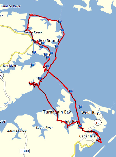
I tack west into the wind to reach the lee of South Marsh Island. The second tack carries me into Pry Cove on the southwest shore. The cove is wide, shallow and, as I had suspected from looking at the charts, excellent protection for just about any wind. But it is only early afternoon, too early to stop for the day. Instead I sail farther and farther into the cove looking for a small opening to Kedges Straits.
I round a point and see the opening. I also see from looking at the shoreline that the tide is down almost two feet. I drop all sails to motor to the cut, soon finding Spartina sitting on the mud. I cut off the outboard, use the oar to push off the mud into deeper water. The channel looks like it might be deeper to the left so I come at it again, this time to the south. I see two sea gulls watching me from near the entrance to the cut, exactly where I had hoped to find a couple of feet of water. They are standing in an inch of water.
I swing around, motor out into open water and raise the sails. I will save that channel for another day when the tides are higher.
I leave Pry Cove and turn south across Kedges Straits. The wind is not quite as strong and it has swung to the SE. The strait, being open to the wind and waves, feels similar to the Hooper Strait crossing from a few hours earlier. I shake out the reef in the main and point up a little higher.
I pass the Solomons Lump Lighthouse and reach calmer water in the lee of Smith Island. I turn to early into Back Cove and find Spartina crossing a shallow sandbar.
I raise the cb and rudder and drift until there are a couple of feet under the boat. Then I sail into the cove, choosing a protected bay about a mile north of where I had anchored two nights earlier. Anchor down at 4 pm.
Sail off anchor 6:25, pretty morning with good northeast wind, a single reef tucked in the main.
Pass in sight Crisfield on the Little Annemessex River, round Island Point and slip out on Tangier Sound at 7:05. Cool morning, slip on foul weather bibs and a sweater. Doing 3.4 against the chop out of the northeast.
At 7:25 making 4.4 to the north, more wind and bigger chop. 7:35 at green "9", sailing into the waves but doing ok.
8:30 round up to tie in second reef, Deal Island to the northeast, making 4.5. Kedges Straits to port. Seems calmer at 8:30. South Marsh Island to port at 9:00.
Steady sailing to north-northwest at 10:10. Bloodsworth Island to port and very rough. 10:45 angle northwest across Hooper Strait, 4.3. 11:20 on the Honga River. Calmer water on the river and making 5.3. Drop the main at Crab Point to look for an anchorage. Can't find one with this wind.
Slip back out on to the Honga and continue north. Anchor down 1:30 off of Parks Neck south of Wroten Island. Tall stand of trees gives us good protection. Set up the boom. Clean up SPARTINA and relax in the afternoon.
Wake to the sound of birds calling in the marsh. Seems like the first time I've heard anything but wind for the last couple days. Sail off anchor with a beautiful sunrise. Full sail on a cool clear morning.
Making 2.1 across Pry Cove. 7:05 out of the cove and jibe towards Solomon's Lump Lighthouse. A very pleasant run down the southwest shore of South Marsh Island, 4.6 in the calm lee of the island. Peanut butter and berries Rx bar, tropical fruit and a buffalo bar for breakfast. 7:40 steady sailing at 3.4 across Kedges Strait.
8:10 crab pots and rough water in the shallow northeast of Smith Island, sailing towards the giant wind turbine in Crisfield. Making 5.4 kts at 8:45. Jibe at 9:00 with an excellent angle for Tangier Island. I look through binoculars to see a tiny blue dot on the horizon, Tangier's water tower.
Near Goose Shoal at 10:20, the gps shows a steady 5 kts and 7 kts in the gusts sailing wing and wing. Make out the channel entrance markers at 10:55, sails down just after 11:00.
It is a well-marked channel but several sticks colored green and red mark shoaling within the channels. I follow the path between the crab shanties, getting a few waves from waterman along the way.
It is still windy and the tide is rushing through the channel near Mr. Park's marina. I try and dock on the down current side but the tide carries me away as soon as I cut power. I swing the outboard to reverse back into the channel and come in on the up current side, a harder landing than I would have liked but not damage done.
I find Mr. Parks getting into his golf cart, say hello and give him $5.00 for the tie. I ask him, because of the pandemic, if the restaurants are open. He tells me yes, "hop in and I'll give you a ride." I say thanks but I want to tidy up the boat first, and the restaurants are only two blocks away.
Lorraine's Snack Bar and Fisherman's Corner are right across the lane from each other. I choose Lorraine's and enjoy an excellent crab cake sandwich, homemade chips and a small salad...plus a couple glasses of iced tea.
I take a walk through the village to see what has changed. Some houses have been fixed up, some fallen into disrepair. I stop at a gift shop and buy a used Hemingway book for $1. Down by the docks a crowd has gathered as the mailboat has come in from Crisfield. Visiting the grocery store I find the shelves distressingly empty. I was hoping to buy a gallon or two of water but none to be had. I do buy a couple small bottles of water at an ice cream stand.
Cast off just after 2:00, motoring past the crab shanties and raising mizzen and jib over the shallows next to Port Isobel Island. I sail down and back along the eastern most ridge of Tangier Island known as Canton, looking for the calmest spot to anchor in the north wind. I find it deep in the "hook" known as Cod Harbor.
Anchor down 3:00. 23.73 NM for the day.
About an hour later I see dark saisl coming around Canton. It is Curt in his Drascombe Longboat Cruiser ANNIE. He has had a rough sail across the bay from the western shore, using The Thorofare to cut across Smith Island and then dropping down to Tangier. It is good to see him.
ANNIE rafts up alongside SPARTINA. We share a toast from a little flask Curt is carrying and catch up with each other. We fix our own dinners and talk our days on the water.
I wake at 6 a.m., no rain is falling but water is puddled along the forward edge of the thwart near my head. I reached out with the sponge and sop it up, squeezing the sponge over the side without leaving my sleeping bag. The corner of the bag is damp, most likely from water dripping down through leak in the boom tent. And I can feel dampness along the edge of my sleeping mat inside the bivy.
It is cold, dark and windy. The wind had swung, as forecast, to the NE. The clouds are thick, dark and very low. I wish I had shoes, the deck is cold.
I motor out of the creek and reach open water at 6:35. Under sail a few minutes later, the wind fails. I motor out of Back Cove and start to cross Kedges Straits under power. The wind returns halfway in the middle of the strait and I sail up Tangier Sound with my sleeping gear spread out on the foredeck, trying to dry the bivy and sleeping bag. I've layered on a couple of shirts, a light-weight jacket and my foul weather gear. The darkness makes it feel colder.
Weather radio says I am dealing with two fronts. One that arrived overnight and is dissipating, another one arriving mid-day. The wind seems to be shifting as I tack north between South Marsh Island and Deal Island. Sun reaches down through the clouds at 8:30 to make me feel a little better.
About a half dozen fishing boats are trolling the fishing area marked as Chain Hole just west of Deal Island. I put out a lure and troll for a while, then bring the lure back in. I can easily troll in the rough chop, but decide that I do not want to have to stand on the cold damp deck and reel in a fish as the boat pitches about. Spartina sails comfortably at a little over 3 knots, no spray coming over the side onto my drying sleeping bag and bivy.
Skies lighten throughout the morning. Late morning the wind swings to the W, maybe the second front arriving. I sail NW at 3 knots to the east of Bloodsworth Island. The wind seems, for the first time today, consistent.
Then wind fails, only to quickly fill back in. Blue skies come with the breeze. It is warm enough to take off the foul weather gear, but I'm enjoying being a little too warm and I leave the extra layer on.
Early afternoon it gets almost hot and I strip off the foul weather jacket and my lightweight jacket as I cross Hooper Strait into Fishing Bay. I consider anchoring at Goose Creek a few miles up Fishing Bay, decide it is too early in the afternoon and turn back to Hooper Strait. The water is calm and surprisingly clear, the warm sun feels good.
I duck back out into Hooper Strait and turn NW paralleling the eastern shoreline of the Honga River at 4.4 knots. We are in the lee of Lower Hooper Island and the water is calm and protected. I sail holding the tiller with my knee and enjoy the afternoon.
Looking at the map I see Crab Point Bay offers protection from the E, S and W. I pick out what I think is Crab Point in the distance, but my gps tells me it is much closer. Soon a small stand of trees marks the point. I round it under a failing breeze and enter the cove. My cb touches bottom as I cut too close to the point, I raise the board and continue on.
The water is clear enough I can see the grasses growing on the bottom. It is quiet an peaceful in the cove. Anchor down just before 5:00.
I've searched the internet - the source of all knowledge - and cannot find a connection between that name and the current Deal Island, but the nearby Dames Quarter Creek might be a link to the long lost name.
I spent a few minutes trying to match places I've visited with names on the chart. The old map, while maybe not precise, does show a near continuous line of islands separating the Sound from Chesapeake Bay. There were more islands back then and they were certainly larger, large enough to support towns and plantations.
The opening that leads through the islands from the Sound to the Bay, now known as Kedges Straits, can be seen marked as Racers Strait. I do believe, prior to the erosion of the islands, the water wood have raced through there.
Back north up near Damn'd quarter, a river and two bays cling to their old names with only changes in spelling. The Wicomico River was once Wighcocomoco River, and Monie Bay of today was once the Little and Great Manaye Bays.
Looking at the old map was a trip back in time, a trip back a few hundred years and a trip back to some of the wonderful sails I've enjoyed on the Tangier Sound. Maybe I'll be out there again next Spring.
I am very glad I sailed on Friday. It rained all day yesterday and today I'm working (can't you tell?)