"When I think of all the fools I've been, it's a wonder that I've sailed this many miles." -Guy Clark

Friday, April 29, 2022

tracking map


 Here is a link to my spot tracking map for the sail on the sounds of North Carolina.   Or you can copy and paste the link below.

https://maps.findmespot.com/s/5L4T

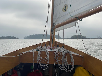
The photo is from one of the two visits I made to Oriental during last year's trip.

Tracking map should go live on Monday.

Tuesday, April 26, 2022

uphauls and downhauls / updated

I received a question from Kent:  Someone was asking about rudder uphauls and downhauls on John Welsford's fb page. Do you have them on SPARTINA?


The answer is yes.  The uphaul and downhaul are the same line, you can see it above with the uphaul going to the back of the rudder blade just behind the rudder stock and the stopper knot of the downhaul on the forward edge of the blade.  The uphaul is fastened to the small line cleat on the port side of the tiller, the downhaul goes in an auto-release cam cleat on the top of the tiller (available from Duckworks).
Hope this helps.  Steve


 P.S.  A question from Michael made me realize that the term "downhaul" is a misnomer on this my boat, I cannot use the downhaul to lower the rudder.   I do that manually, reaching over the transom and pushing the rudder into place.  I then put the "downhaul" into the auto-release cam cleat which holds the rudder in place.

Friday, April 22, 2022

hauled out


I motored SPARTINA down the southern branch of the Elizabeth River this morning to the boat ramp.  She is due for a little maintenance that I need to do next week before heading south for the spring sail on Pamlico/Albemarle Sounds.

This trip will be a walkabout style trip with no definite plans, just any which way the wind blows.  I do have a list of places I would like to visit, the usual spots like Oriental, Beaufort, Little Washington and New Bern.  I do want to to make it to both Ocracoke and Roanoke Islands, it has been a few years since I sailed to either.  I've got three to four weeks so there should be time to visit most of those places.  And of course there are the favorite isolated little anchorage on creeks, rivers, bays and coves.   

Next week will be maintenance, packing food and gear.  Then I'll be ready to go as soon as we get a good two or three day weather window to start the trip.

Wednesday, April 20, 2022

a dog's life


 A nice sail today, light winds and cool temperatures.  A few snowbirds heading north, including this well-worn schooner with a dog on board.

Sunday, April 17, 2022

of time and tides, part two

Bobby Asher just had a nice cruise to Cumberland Island on his John Welsford Pathfinder "LAGNIAPPE."  It sounds like he had a great time.  He sent me this video clip of the running tide at the dock where he launched in St. Marys, Georgia.  I put it here just to give an idea of what the currents can be like on the lower Mid-Atlantic coast.  Thanks for letting me share it, Bobby.


In the last post I talked about dealing with the near constant tides I experienced during the Sea Islands sail.  So tides helped, others not so much.  There were two places where I experienced tides that were simply too strong for my Suzuki 2.5 four-stroke outboard.  There is a simple solution that I used in both places:  Stop, anchor and wait out the tide. 


The first place was Elliott Cut on Wappoo Creek, within a mile or two where I launched SPARTINA (it is the narrow area at left above with the blue arrow pointing towards the Stono River).  My Charleston friend Pete had warned me about the tide ahead of time, plus I had read some other warnings online.  Here is one captain's experience.

I came through Elliots Cut today about an hour before low tide, heading south. Tide was furious against me. 36′ sailboat. At 3/4 power I could only manage 1.9-2 knots but could maintain control. Thankful no other boat in cut. Would recommend waiting until slack tide, go like heck and get through.


For my first attempt at the Sea Islands, which you can see below, I headed right up to the cut thinking "it can't be that bad."  It was that bad, like a fast moving river with eddies walled by rip rap on both sides.


I quickly retreated, dropped anchor and waited an hour for the current to drop.  And you can see the difference below.  Calm water and an easy passage.  Having learned my lesson I launched on my second attempt just as slack tide approached, making for an easy passage to the Stono River.


--------------------------


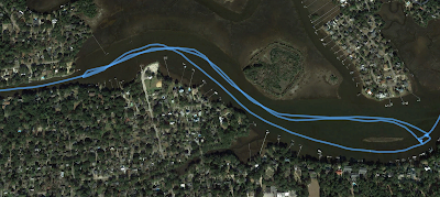
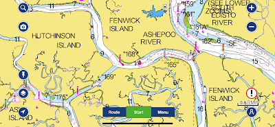
The second spot with a running tide that stopped me was the Ashpoo-Coosaw Cutoff.  You can see my track below.


I made two attempts to sail through the opening at the lower left in the track screen image above.  It was a bit like a washing machine with boiling water and confused currents.  I then attempted to anchor in the shallow just up the Ashpoo River and could not even get my anchor to the bottom.  At that point it was obvious that I would not even be able to power through.  So I dropped anchor and waited out the tide.  Easy passage after that.


Both the cuts above may have been man-made, or at least man-made expansions of smaller waterways.  With peak tides I found them impossible to transit.  In the future, when I pass through and the tide is running it will be nothing more to me and a good excuse to drop the anchor and take a nap.  Nothing wrong with that.

---------------------------


I have had several days of excellent day sailing on the Elizabeth River, two or three hour sails that I find so relaxing.  Maybe a couple day sails then I will haul SPARTINA out to bring her home.  A little spring maintenance before heading to North Carolina for the spring sail in early May.

Saturday, April 9, 2022

of time and tides, part one

Tides are a near constant presence when sailing south from Charleston, much more so than what I find while sailing on Chesapeake Bay and the Sounds of North Carolina.  I thought I would look a single day's sail and the tides I encountered, this being day four with the sail from Beaufort to the New River behind Daufuskie Island. 


 1 - Casting off from Beaufort it was the beginning of the ebb tide, a helping tide that carried me down the Beaufort River.

2- Passing Parris Island Recruit Depot (I could hear reveille playing) the  ebb tide was running and we were making 6.4 knots, the wind was good but some of the speed came from the tide.  


3- Approaching Parris Island Spit and the mouth of the Beaufort River the tide was strong enough to pull crab pot markers nearly under the surface, I would guess this was full flood tide.  As I rounded the spit I could no longer feel the tide, maybe I was in the "shadow" of Parris Island.  Once around the spit on to Port Royal Sound it was full ebb tide which can run at a couple of knots.  With the light wind at that point I could only hold my own against the tide and not make any progress up the sound.  So I motor sailed across the sound to Skull Creek.

4- Near Dolphin Point there was swirling water and a tide line.  Once I crossed the tide line I could not at first feel any tide.

5- Passing Skull Creek I could once again feel the tide, an incoming tide, water flowing from Port Royal Sound into the creek and helping us along the way.

6- Off Windmill Harbor a helping tide but it was hard to tell as the wind was very good on the port quarter and we were making 5.0.

7- On Calibogue Sound approaching the Cooper River both crab pot markers and boat speed told me that it was a flood tide, water coming up the sound and we were sailing against it.  

8- Once on the Cooper River that very same flood tide was helping us.  Before rounding the corner into the river the tide was against us, once around the corner it was with us and we were making 4.4. 


 9- At green marker "37" I could see from the marker's piling the tide was once again against us.  It was still a flood tide but somewhere along the way we crossed what my Charleston fried Pete tells me is called the "head of the tide."  When we first entered the Cooper River the flood tide was water flowing from Calibogue Sound.  When we crossed the head of the tide the flood tide was water flowing in from the inlets just north of the Savannah River.  I did not have to work against that tide for long as the wind was very good and soon we turned off the Cooper River for the anchorage on the New River.

So you can see the tides are an interesting part of sailing the lower Mid-Atlantic.  If there is any decent wind I found I could sail against most of the tides just fine.  And if it was a helping tide, well that made for some nice sailing. 

There are a few places along the way, mostly man-made cuts connecting creeks and rivers, where I could not sail or even motor against the tide.   I'll get to those places in another post.

Tuesday, April 5, 2022

a Pathfinder in town


A brief wonderful sail this morning, steady southwest breeze and nice blue skies.  Cruising boats are starting to show up in Craford Bay.  The boat in front will be heading to Europe soon, the second boat on its way to the Florida Keys.  


The river is starting to come to life.  The AMERICAN ROVER is rigged with new sails, ready for her first sail of the season late this week.


 I headed in early to go see Bobby Asher and his Pathfinder LAGNIAPPE at Little Bay Canvas.  He had stopped in to talk with Angel about a boom tent for his boat.  Sounds like it might be similar to mine but with a few changes to suit Bobby's boat and his style of cruising.  It was great to see him, and also very nice to see Angel who has done some really nice canvas work for me over the years.  I'm going to shoot a few detail photos of SPARTINA'S boom tent to show Bobby and remind Angel how my tent is set up.  Good luck to both of them on the new project.

Sunday, April 3, 2022