"When I think of all the fools I've been, it's a wonder that I've sailed this many miles." -Guy Clark

Monday, July 30, 2012

further or farther?

I've never understood the difference between "further" and "farther" and a quick google search tells me there is not much of one when the words are used as adverbs.  Some sites say "farther" is preferred.  


I believe the word is being used as an adverb in the sentence "We might go a little bit farther."  This is what Bruce and I were talking about today in a phone conversation.


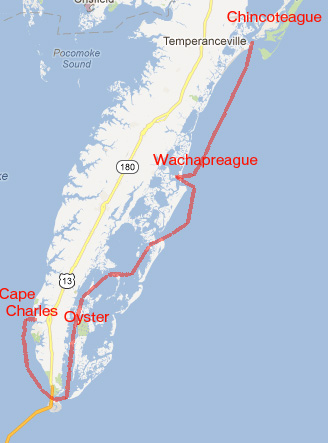
My work schedule is very busy early in September, the result being a little extra time off later that month or early October.  So maybe an extra day or two on the water.  Our goal is to reach Ocean City, Maryland.  If, and that is a big if, the weather in tides cooperate we could possible make Chincoteague or Wachapreague.  With an extra day, and - again - cooperating weather and tides, we could possibly go a little bit farther and make Oyster or even round the bottom of the peninsula and reach Cape Charles.  We've still got to check on flight schedules and a few other things.

At the very minimum, having the extra day or two gives us more weather days.

steve

Sunday, July 29, 2012

a steady breeze


A light but steady breeze made for a comfortable day on the water.  The wind, surprisingly for mid-summer, was out of the north.  Peaking at maybe 10 miles an hour, the wind was in the five to eight range most of the day.  Nothing special, nothing exciting. Just a relaxing day under sail.

Panko crusted crab cakes with a hint of lemon and jalapeno, sweet potato fries and mango salsa for dinner.  Some days are just like that.

steve


Saturday, July 28, 2012

figs for breakfast, fall trip

An unexpected taste of fall arrived this past week.  The fruits of one of our fig trees began to ripen.  These are known to me only as "mystery figs."  I bought this tree in the fall of 2003 just a few weeks after Hurricane Isabel.  The nursery, which was located down in the swampy area near the North Carolina state line and specialized in fruit trees, had lost all the markings on their young trees to Isabel's winds.  Growing five or six types of figs at the time (the couple that ran the nursery has since retired and closed the nursery), they no longer knew which was which.  All the trees were marked as "mystery figs" and sold at a discount.


We have three fig trees in our yard.  The celeste fig tree produces the smallest fruit with dark red, rich flesh.  The golden honey fig tree has always been the most productive, growing a slightly larger fruit with white flesh.  And the mystery fig, which produces the largest fruits, has until this year been the least productive.  This season, maybe because of the mild winter and hot, rainy summer, all three trees are loaded with figs.

Ripening from mid-August to early September, the figs are for me a harbinger of the coming fall.  The mystery fig, though, is living up to its name and ripening now.  Fine by me.  In the heat and humidity of summer it is a nice reminder of the coming cool fronts from the north.


Above is a map based on the discussion I had with Bruce the other evening.  It shows our starting point and possible anchorages.  The end point of the trip will be determined by weather.  The places marked are....

  • Rock Hall, the starting point
  • 1 - there are a couple of creeks a few hours north of Rock Hall for the first anchorage
  • 2 - Herring Creek, just around the corner from the entrance to the C and D canal
  • 3 - Maurice (pronounced "Morris") River Bay area
  • 4 - Cape May
  • 5 - inside Indian River Inlet
  • 6 - Ocean City  (which is most likely where we will stop, but if the weather doesn't eat up the extra days built into the schedule, then....
  • 7 - Chincoteague (pronounced shing-kuh-TEEG)
  • 8 - Oyster, not on the map and I would be surprised to make it that far
We are a little less than two months out from the trip, time to start thinking about food supplies.  Bruce, what's for dinner?

steve

Thursday, July 26, 2012

a little light reading

I spent about 40 minutes on the phone with Bruce last night going over plans for the fall trip. We talked about the route, the options, equipment, tides and rental cars.  There are still a lot of details to be worked out but I think we have the basic plan set.


When we talk about the trip we often refer to Washington Tuttle's circumnavigation of the Delmarva Peninsula.  The only record I have of that sail is four wrinkled, annotated pages that I printed off the internet many years ago.  I can no longer find the trip on the web.  

I keep Tut's story in a folder along with print out of several other small boat journeys that I have come across over the years.  I read and reread them for years before building Spartina.  And once Spartina was built I read them again to steal ideas for small boat cruising.  Along with the Delmarva circumnavigation there are stories about David Perillo sailing his Navigator in the Fiji Islands, a Sea Pearl trip to the Maquesas off Key West, and sailing southern New England in a Wayfarer Dinghy.  They are all a pleasure to read. 


A couple of the best stories in the folder come from the old Small Boat Journal, a magazine that existed from 1979 to 1991.  I had a subscription for years and even now find an old copy or two tucked away here and there.  I really miss that magazine.  Fortunately someone by the name of Chris Councill has put many of the SBJ stories online.  You can find an index here.   

Above is the cover art for Dinghy Down the Keys, published in SBJ February/March of 1990 (their last full year of publication).  Lowell P. Thomas tells his story of sailing a home built 14' Bahama style dinghy - built for $300 - down the Florida Keys.  Thomas tells us about the boat, the trip, navigation and sleeping on board.  It is the story of mangroves and crystal clear water, a simple boat and a simple, relaxing journey.


And above is the cover art for Down Pamlico Sound in a 17 foot Open Boat. ( Boy does that title strike a chord in my heart.)  I first read that story in the spring of 1988 while living in Waco, Texas.  I did not know it at the time, but I would soon be moving from Texas to the mid-Atlantic with Pamlico Sound just an hour or two away.  Tim Lemmond's story is about sailing with his father on board a Bost Whaler designed Harpoon.  The planned 17-day voyage was less than a success, they were half way into the trip when the boat was dismasted approaching Ocracoke's Silver Lake.  I think of their trip now and then, and look forward to the day when I can sail Spartina down that same channel to the harbor at Ocracoke.


Late in the evening I sometimes find myself digging out the file to read these stories.  While I once read them to fuel my dreams, I now read them to compare notes.  I can hear the wind howl, feel the boat heel and enjoy their voyages as much as I've enjoyed my own.  And they remind me how much fun it is to hop on a small boat, cast off and just sail away.

------------------------------------------

It is hot today, hotter tomorrow.  The weekend forecast says it should cool down (relatively speaking) to the low 90's.  But wind is a problem with a forecast of a mile or two per hour.  I do hope to get out for a sail this weekend, but it will take more wind than that.

steve

Tuesday, July 24, 2012

a day at the beach, Cape May


As I research our upcoming trip I've become curious about Cape May.  I hear and read lots of things about a nice little summer town on the beach, quaint houses and good seafood.  Just the kind of place we would like to visit.  And of course I hear and read tortuous things about the water, fast running tides and serious chop.  I suspect there is some truth to it all.    

I wanted to take a peek for myself, so I searched around the web this morning to find this Surf Cam.  The camera is located at "The Cove" in Cape May.  Watch the view for a moment and you will see the camera swing from east to west where you will get a view of the Cape May Lighthouse.  The weather conditions as of now - Tuesday morning - show 5 kts of wind and waves of one foot.  It looks, at least at this moment, like a nice day at the beach.  I wish I were out there sailing.

steve


Monday, July 23, 2012

planning - Chesapeake Bay to Ocean City

A hot, muggy day without much wind.  I might have gone sailing.  I might have drifted and baked under the summer sun.  Instead I'm doing some planning.


I connected my gps to the laptop and using Garmin's Homeport software  put waypoints on both shores of Delaware Bay.  You'll see that there are more waypoints on the Delaware shore, but those are mostly narrow, marshy creeks with strong tides where we would anchor only if we need to seek shelter.  Using Washington Tuttle's experience as a guide book, those creeks should be avoided.  Here is his description..

There were threatening clouds over the Jersey Shore so I kept a sharp lookout for inlets.  The sun and the breeze were strong.  I found an inlet in the marsh.  The flies filled in behind my glasses, flew up my nose and in my ears.  I soon left that place in a hurry.

The Jersey shore has fewer but better anchorages.  I think Bruce and I both prefer the Jersey side, both because of those anchorages and because it would give us the chance to visit the nice little town of Cape May, New Jersey.


The Chesapeake and Delaware Canal is 14 miles long.  Ideally we would like to start the day at dawn anchored nearby in either the Elk River or Herring Creek.  Sailing is prohibited (and not practical) in the narrow, heavily trafficked canal, so we will be motoring the entire length.  My guess is three or four hours to pass through the canal, starting with a tide running against us, finishing with a helping tide. It would be nice to get through the canal by late morning.


Once out of the canal we sail south on Delaware Bay, clinging at first to the Delaware shore because of the nuclear power plant and a commercial ship anchorage close to the Jersey Side.  A ways south, though, with a compatible wind and tide we would like to cross over to the Jersey Shore heading southeast to the Maurice River Cove area which offers all sorts of protections in various rivers and bays.  Plus there are a handful of marinas nearby in case we need supplies, fuel, etc.

If the wind and tide are not compatible and we have to stay on the Delaware side, we'll aim for the St. Jones River, with decent protection and a marina at Bowers Beach.  Washington Tuttle, after leaving the fly filled creek, spent the night there.  A good restaurant was there then, and I think it is still there now.


So we end up in either Cape May, New Jersey or Lewes (pronounced Lewis I believe), Delaware.  We'll want to head south from there to Ocean City, Maryland.  I've drawn out a few options above, everything from off the beach from Cape May to Ocean City - a very healthy 40 miles - or taking the Lewes and Rehoboth Canal down to Indian River Inlet, then going outside to Ocean City, which is what Washington Tuttle did on his circumnavigation.

With the inlets at Cape May, Indian River and Ocean City, the tides will be critical. That will be my next little bit of research.

steve

steve

Friday, July 20, 2012

Delaware Bay, revisited

I've been doing a lot of "revisiting" as of late.


While wrapping up the log from the June trip to North Carolina I started thinking about the coming trip over the top of the Delmarva Peninsula including Chesapeake Bay, The Chesapeake and Delaware Canal and Delaware Bay.  I had researched Delaware Bay last fall and wrote a less-than-favorable post called "the nastiest, most miserable body of water".   A little harsh, I suspect.


I googled "Delaware Bay" and came across the tydb.org site.  The name stands for Thank You Delaware Bay, and the site celebrates the bay for food (oysters, crabs and stripers), medicine (it is the home to the largest population of horseshore crabs, which are used in medical research), wildlife (tens of thousands of acres of marsh and tidal flats and I know I will love those areas), recreation (parks, wildlife refuges) and the view (can't beat the water view, particularly when it is seen from a small sailboat).


The site, which I will explore a bit more, gave me a new outlook on the bay.  Sure, I know the issues of the tide going one way and the wind going the other, plus the fact the bay includes a heavily trafficked shipping channel.  But it is water and wetlands, fishing and exploring - all that stuff I love.

I don't want to sound like an optimist or anything along those lines, but I'm definitely rethinking my opinion of Delaware Bay.  I mean who wants to spend the next several weeks planning a trip on a miserable body of water.  It's a big wide bay, lots of creeks and inlets on either side, plenty of room for both Spartina and the big ships.  I need to connect the gps to the laptop and start making waypoints.  I can't wait.

steve

Thursday, July 19, 2012

the camera, revisited

What was I thinking?


It seems like I have never been happy with my Pentax Optio W90 camera.  I bought it with high hopes, then was quickly disappointed.  Focusing never seemed quick enough, images weren't sharp enough and it seemed to eat batteries for breakfast.


But as I looked at my files from this last cruise I found myself starting to thing "Hey, these are some nice photographs."  That thought led me to look at photos from my last three trips, some of which you can see here.  Not too bad.  I'm starting, after a year and half, to like this camera.


I guess it is hard to say the W90 is a bad camera when a photograph shot with the camera, above, was used as the cover shot of Chesapeake Bay Magazine.  There are some pretty high technical requirements for magazine cover reproduction and this W90 pictures seemed to work out just fine. 

Take a look at the post titled "the boat" and  you will see that the first eight images were shot with this camera.  Those are, at least in my opinion, some pretty nice photographs.  


Some of this is the learning curve.  I finally figured out how to turn off all the junk - smile indicators, etc - and just use the camera as a waterproof point and shoot.  And some of it is getting out and using the camera, giving it a chance to see what it can do.


Even my opinion of the battery consumption has changed.  I took six batteries on this last eight day trip.    By the evening of the second day I had drained one battery.  During lunch in Atlantic the next day I recharged that battery and topped off the second battery.  Those two batteries lasted the rest of the trip.  I never touched the other six batteries.

The only area where I ran short was on my storage card.  I left behind (unintentionally) my extra cards and by day seven I had filled up the two gig card.  The last day of the trip I was going through the shoot, deleting images so I can shoot just a couple more photographs.  But that was all my fault, not the camera's.


Check out the detail in the fish photograph above.  The crispness and tonal qualities of that picture would be a plus for any camera.


One earlier opinion that I will stand by is that the video is terrible.  I can live with that.  I'm not all that interested in video.  

For right now, this is a pretty good camera to have on board.  I will keep it and use it until I find something that is a lot better.  That may be a while. 

steve


Tuesday, July 17, 2012

day eight - short sail to Hobucken

I wake to clouds, dark and heavy with rain, roaming over Pamlico Sound.  Spartina is dry, but very buggy.  Three mosquito mornings on this trip, one of the buggier trips I've made.  But I've got it down to a science now.  Unzip the mosquito mesh from the bivy, hop out, crank up the outboard and haul the anchor.  Motor just a hundred yards out of the creek, leave the bugs behind and tidy up the boat while adrift on the open water.  


Under sail before 6 a.m. with a light south wind.  A little after six I can see the ICW at the far end of Jones Bay.  The wind swings to the southwest, still light but strong enough for a pleasant sail.  A couple of tacks along the north shore of the bay, passing close by a crabber working his line of pots.  The clouds clear away and it is a pretty morning with blue skies.


I drop the sails at 8 a.m. and motor toward the ditch.  It seems like a long time ago that I launched out of Hobucken.  Eight days, a couple of hundred miles.  Swan Creek, Beaufort, Cape Lookout, Core Sound, the Pungo River.  A good book, some nice meals and excellent sailing.  A couple of storms, bugs.  Sunrises that you won't find anywhere else.  Birds, otters swimming on the ICW and wild ponies walking on the beach.  Wind and pretty water.  Solitude.

I see the boat house at the end of the ditch.  Shawn is walking over to help with the lines, help me haul the boat out of the water.  He asks about the trip, but already knows much about it as he watched my SPOT track and kept an eye on me.  I thank him for his hospitality.

By 10:30 I'm all hooked up and driving home with Spartina in tow.

steve


Monday, July 16, 2012

day seven - speckled trout for lunch

Dawn on Bell Creek.  Calm water, no wind.  Mosquitoes.  I hop out of the bivy, start the outboard and haul in the anchor.  Soon I am drifting out in open water, cleaning up the boat and chasing away the bugs.  


Sails up before 7.  Barely a breath of wind as we make a slow drift south across the Pamlico River.  I can hear the birds in the marsh.  Schools of bait fish ruffle the surface of the glassy water.  Very peaceful, which is nice after last night's storms.

At 8:30 we are halfway across the river and I can feel the heat of the day.  I start the outboard and motor towards Pamlico Point at idle speed.  I can see the purple and white jellyfish just beneath the surface of the water.  Blue crabs swim by, very intent on getting somewhere.  Three boats drift off of Pamlico Point, people on board casting lures.


There is a bit of wind and I shut down the outboard, sail to the grassy shoreline just west of the point.  Three casts and I have a speckled trout in the boat.  It is barely legal so I put it back in the water. With the light breeze out of the southeast I work up and down the shoreline for about fifty yards, keeping Spartina even with a line of crab pots.  From there I can cast right up to the grass line and work the twin tailed lure back along the shallow bottom.

I hook two more trout but lose them before they get to the boat.  I need to buy a hook sharpener.  A few more casts and I bring in another trout, this one worth keeping.


I turn Spartina away from shore, round Pamlico Point and anchor in Mouse Harbor.  It is time for Sunday brunch.


Sweet potato slices with cajun seasoning sizzle on the grill while I clean the fish.  I wish I had a lime.  Lightly seasoned, the filets go on the griddle.  On a calm morning in Mouse Harbor I enjoy the unexpected brunch.

After packing away the cooking gear I jump in the water for a swim.  I clean the bottom with a scouring pad for the third time on the trip.  I swim and relax and enjoy the coolness of the water.  Then I feel the burn as a jellyfish drifts by.

Out of the water I search my first aid kit for ointments.  I find two, neither of which seem appropriate for treating jellyfish stings.  I mix the two together and rub them on my back and my lower legs.  The combination seems to work.  


The wind is east, swinging to southeast as I leave Mouse Harbor and sail south along the Porpoise Bays and Middle Bay.  Just two tacks as we sail south at between four and five knots.  We pass Sow Island Point at the mouth of Jones Bay at 3 p.m.  We cross the mouth the bay and enter a cove behind Boar Point.  I have sailed past the cove three or four times over the past few years, always thinking it would make a nice anchorage.  I round up and drop the anchor before 4 p.m.


Hobucken and Pate Boat Yard are just a few miles up the river, I could easily be there by dark.  But it is a pleasant evening and I've got a few more chapters to read in my book.

steve