"X" marks the spot, SPARTINA'S approximate location in the sand hook at the south end of Tangier Island the night of storm on day 4.
   URGENT - IMMEDIATE BROADCAST REQUESTED
   Severe Thunderstorm Watch Number 88
   NWS Storm Prediction Center Norman OK
   1230 PM EDT Mon May 14 2018

   The NWS Storm Prediction Center has issued a

   * Severe Thunderstorm Watch for portions of
     District Of Columbia
     Western and central Maryland
     Southeast Ohio
     Southern Pennsylvania
     Northern Virginia
     Northern and central West Virginia
     Coastal Waters

   * Effective this Monday afternoon and evening from 1230 PM until
     900 PM EDT.

   * Primary threats include...
     Widespread damaging winds and isolated significant gusts to 75
       mph likely
     Isolated large hail events to 1.5 inches in diameter possible
     A tornado or two possible

   SUMMARY...Strong to severe storms will quickly evolve into a squall
   line that should progress east then southeast across the central
   Appalachians towards Chesapeake Bay. Damaging winds will be the
   primary hazard with a brief tornado or two possible.

   The severe thunderstorm watch area is approximately along and 85
   statute miles either side of a line from 40 miles northwest of
   Parkersburg WV to 20 miles south southeast of Baltimore MD. For a
   complete depiction of the watch see the associated watch outline
   update (WOUS64 KWNS WOU8).
I do wish I could have used my phone to see the storm coming. Had I been able to use Dark Sky or some other app I might have seen that the storm was far enough away that I could have gone back the the marina. But there is no cell tower on Tangier, it is virtually impossible to get any sort of cellular connection.
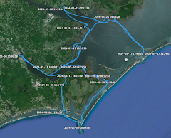
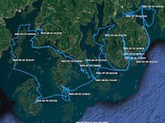
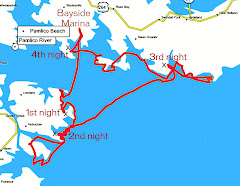
Above is SPARTINA'S track during the storm. Back and forth. Below is a wider view of the anchorage.
Because of the lack of cell towers I did not receive storm info from Barry, both a heads up before the storm (I also missed out on a warning from Mary Lou) and a recap afterwards. He told me the nearest weather buoy, located at the mouth of the Potomac River, showed steady winds at 28 mph and gusts to 64, then at another time sustained wind at 50 mph with no data for the gusts. I appreciate Barry shared this info, but kinda knew it already.
Below is the overnight track from the storm that shows our position during the storm at the right with wind coming out of the west then swinging back around after the storm had passed. The anchor held.
I've had a few questions about the anchors. I'll talk about that in my next post.











No comments:
Post a Comment