"When I think of all the fools I've been, it's a wonder that I've sailed this many miles." -Guy Clark

Thursday, April 2, 2009

weekend forecast


I've got a four day weekend with a nice forecast on two of the days.  I hope to get out Saturday.  Winds are supposed to be in the 14-16 mph range, clear skies and temperatures of about 60 degrees.  

One of the nice things about doing this blog is that I've been digging back through the files of old photos and finding images I had forgotten about.  Bruce and I did an "edit" after the trip to pick out about two dozen photographs for Duckworks and some other publications.  After that edit I forgot about all the other images.  

Bruce shot the photograph of me (top) as we were leaving Oriental.  I don't think the sun was fully above the horizon.  That's the Oriental Marina & Inn where we stayed back on the right tucked behind the trees.  The small building to the left of the mizzen mast is a coffee shop.  I think it was called The Bean.  When we arrived we tied up at the public dock right in front of The Bean and within minutes we had several of the regulars down on the dock asking about Spartina and our trip.  Plus we had several offers of rides to get gas and supplies.  Oriental is a great little town.  They have a nice online publication down there called TownDock and I enjoy keeping up with the news there.

I shot the photo of Bruce as we were anchored in a foot or two of water off of Bird Shoal near Beaufort.  I like this picture for two reasons.  One, Bruce looks nice and relaxed.  This was five days in to our trip in '07 and we were both very comfortable with the cruising routine.  And two, the tumblehome on Spartina can clearly be seen.  The tumblehome is where the upper planks tilt inward and the beam of the boat narrows as the distance above the waterline increases.  You can see that on the transom where the upper planks tilt in towards the top.  Designer John Welsford says that the Pathfinder's hull was inspired by the Cobles used by fishermen on the northeast coast of England.  John modernized the hull and adapted it to the home builder.  But he kept that classic look and good sea-keeping ability.  Thanks John!

PS - That nice inflatable pfd with built in harness that I'm wearing in the top photo is a gift from Bruce.  He brought two back to the east coast for the trip.  After the trip I tried to return them to him.  He said no, they belong to the boat.  Thanks Bruce!

Monday, March 30, 2009

On The ICW

Steve's last couple of posts talk about canals and the ICW. I liked the photos he choose to illustrate some of the challenges and beauty boaters may face navigating these types of waters. I know we had a few challenges ourselves as we headed down the ICW towards Beaufort from Oriental. I had read about the canal systems on the east coast in many a history class over the years, but I had never actually seen one. So on the way down to Harkers Island for our cruise, Steve stopped off by the Dismal Swamp Canal so I could take a look.

Here is my view of the Dismal Swamp Canal. It was actually pretty.

I really wasn't too sure what to expect the ICW would look like. I had viewed our route on Google Earth months before our trip started. But even from that vantage point I couldn't tell what it would be like. It was very different from what I expected (and there are many, many different sections all up and down the east coast). The first part was very open, wide and resort like. The homes were scattered through forested shoreline. The area was very stunning in the early morning sunlight.

The ICW is highlighted on this Google Earth view.

We initially started our ICW voyage under sail alone. But as the waterway started to narrow and change direction and the wind slowly fell off we decided to start the motor. We continued on under motor and sail. As the waterway began to narrow further and the current started to increase we came upon a dredge busy deepening the channel.

Dredgeing the channel is a full time operation.

There were several small work boats chugging about, moving pipe and supporting the operation. Steve contacted the dredge, communicated our intention and direction and we moved on past. However, just after we cleared the dredge our motor sputtered and came to a stop, out of gas. I moved forward and retrieved the gas can. Steve filled the gas tank and attempted to start the motor. It wouldn't start. We waited a few moments and tried again with no success. Five minutes passed and still no power. We were now drifting towards the shore and one of the work boats. There was traffic from other boats moving in both directions. As a rookie, I was thinking I should be getting out the paddle just in case. Steve just sat patiently and with the shore and drifting tree limbs fast approaching, he gave the engine starter cord a tug and the motor sprang to life. Ok, that was fun. We motored on.

Smooth sailing once again.

We had great skies.

We had been having some flooding trouble with the motor earlier. It seemed if we completely refilled the gas tank we would experience the flooding problem, so we only did partial fills. It seemed to help, some. We tried to work out our position for refueling carefully so as to avoid another mid-channel incident. We could go about two hours on a tank of gas. The flooding problem didn't happen each refueling, but we were prepared just in case. After several hours of very pleasant cruising, we knew we needed to refuel one last time and then put in at a marina to fill up the gas can for the remainder of the trip into Beaufort. Steve had a marina identified on his chart. When the motor started to sputter, out of gas, we refueled, and to avoid the dreaded flooding syndrome we only put in enough gas to reach the marina. Steve kept an eye out as we neared the location indicated on the chart.

I'm sure it's just around the next bend.

Now we had the main sail flopping loosely in the light breeze with the jib and mizzen doing all the work along with the motor. Everything seemed to be working out perfectly as the marina appeared ahead. Steve scanned the marina with his binoculars and discovered it was more a repair and storage yard and had no fuel station. Bummer.

The next marina was miles on down the waterway. So on we went. Half an hour later we saw the marina and it was a full service one! It looked like we were going to just putt putt in and tie up. Wrong. We ran out of gas about 200 yards away. Fire drill time. I got the gas can, Steve filled the motor's gas tank, pulled the cord and the flooding problem reared its ugly head once again. This time we were in the middle of the channel, the current moving smartly and lots of other traffic. We were fast approaching the marina and could not afford to pass it as it was the last fueling opportunity until Beaufort. At what seemed like the last minute, Steve quickly tightened the main. Spartina picked up speed in the light breeze and current and sprang forward. Steve then pushed the tiller hard over and we shot into the marina. He slacked the main and jib and we just glided up to the slip. I tossed our line up to the dock hand and we came to a stop. I was totally impressed as were several onlookers standing on the dock. It looked like we knew what we were doing. Yes we meant to do that!

We completed the rest of the journey to Beaufort without further incident. We didn't experience the flooding problem again for the remainder of the trip. Up until that part of our trip we had been in open water and had plenty of room to manuver. The narrow channels of the ICW posed some interesting challenges for us. As we are preparing for our next trip this May, I can't help but wonder what lies in store for us. That is what I like about outdoor adventures, anything can happen. How you handle yourself can make all the difference. With Steve as the skipper, I'm not worried about how we will fare.

Bruce


small boat challenges

I received a note from DancesWithSandyBottom about the choice of the Harlowe Creek Canal for the North Carolina Watertribe event.  He said part of the selection was to provide a "small boat filter" to challenge the participants.  I think canal in fact will be the most difficult part of the race and it will prove to be a great choice by the organizers. Information about this old canal is hard to come by.  DWSB and a few others plan to transit the canal this spring to see what it is like.  I had thought the depth at low tide was one foot, but now I look closer at my chart and see that it is one-half foot(!!!).  DWSB also mentions a 2 mph current, plus the possibility of three fixed bridges.  My chartbook shows at least two bridges, one with a seven foot clearance, the other with eight (not much room for masts).  There also looks like there might be a third bridge, but it is marked only with a overhead power cable at 38 feet.  Needless to say, passage on that canal will be a challenge.  But a challenge is exactly what the Watertribe crowd is looking for. 
I do not know much about kayaking, but from the trip Bruce and I made in the area I can see there will be some additional trials for sailboats.  The Grayden Paul bascule bridge (above) at the west end of Beaufort opens on the hour and half hour between 6 a.m. and 10 p.m.  Overnight it opens on demand.  The current rips through there pretty good so it would not be a great spot for a sailboat without power (one of the Watertribe rules) to have to wait for a bridge opening.  Timing one's arrival or lowering the masts might be the way to go.

Once past the Beaufort waterfront check point there is Taylor Creek to deal with.  That is Bruce up forward on Spartina as we headed east on Taylor Creek before dawn on the final day of our trip.  The creek runs between Beaufort and narrow Carrot Island.  Luck was in our favor as we got to the dock and found the current ripping to the east - exactly the way we wanted to go.  I don't know how fast it was moving, a few knots at the very least (could I have read somewhere four or maybe six knots???), but I would not want to sail, row or paddle against that current.  A close look at the tide tables could save a lot of effort for competitors.
The combination of the canal, bridges and tides from the Neuse River to the Harkers Island area will make for some interesting logistical and timing decisions.  It is those challenges that will make the NC watertribe event interesting and exciting.  
I won't be making the challenge this year.  Bruce and I already have plans to be sailing north up Chesapeake Bay to the Mid-Atlantic Small Craft Festival.  In fact I'm not sure I'll ever compete in a Watertribe Event.  The Pathfinder is the perfect boat for the cruising, but I don't think it is meant for this sort of racing.  It would be tough to launch Spartina off the beach (a Watertribe rule), it is too wide to be practical for rowing and making the the masts easy to drop would require some serious rebuilding.  Plus I have this tendency, when I spot a nice protected cove on a sunny day, to drop anchor, read a book and maybe take a nap (that doesn't help much in the competitive standings).
Maybe what I'll do is a time a cruise in the fall of 2010 so that I'm sailing east along the north shore of Cedar Island and enjoy the beauty of all the small boats as they start the race, then head down Core Sound and catch them again as they pass by Beaufort and Harkers Island.  What do you think Bruce?

-Steve

Sunday, March 29, 2009

headed north

I've been caught a few times lately at the old swing bridge on the Chesapeake and Albemarle Canal near my house.  Yesterday I had to wait while five boats, one sail boat and four offshore power boats, passed down the canal.  I don't particularly like waiting at the bridges, but I do like what the boat traffic means.  Spring is here and the snowbirds - boaters that take their boats south for the winter to Florida and points beyond  - are heading back north.  We will have a few more cold spells, but it is getting to be time for flip flops, tee shirts and sailing.
Above is the old Dismal Swamp Canal in Deep Creek.  There are two canals that connect Chesapeake Bay with the North Carolina Sounds.  The Albemarle and Chesapeake Canal is the larger of the two and gets the most traffic, anything from pleasure boats to barges and other commercial vessels.  The Dismal Swamp Canal, which runs down the east side of the (unfortunately named )Dismal Swamp, is the older canal.  Narrow, with overhanging trees on either side, it is a very pretty trip (that is the Dismal Swamp Canal in the bottom photo).  I made the passage from Deep Creek down to Elizabeth City in North Carolina and back a few years ago with my friend Paul aboard his Tartan sailboat (you can see his boat just to the right of the red navigation light in the photo above).  Peaceful and quiet, it was a great trip.  I'm sure there is a cruise there for Spartina some day.  Maybe head from Deep Creek down the Dismal Swamp Canal to Elizabeth City, down the Pasquotank River and over to the North Landing River, and then back home via the Albemarle and Chesapeake Canal.  I'll add that idea to the list.
Those are snow geese.  They winter on Back Bay and Currituck Sound, feeding during the day on the thousands of acres of nearby farm fields in North Carolina.  They are heading north too.

A Correction

I mentioned a few posts ago that Bruce and I had made the same trip that the EC kayakers are proposing for a North Carolina Watertribe event.  For the most part I was correct.  But now that I look a little more closely at the charts I see that they are taking a different canal from the Neuse River to the Beaufort area.  Bruce and I took the ICW, also known as the Adams Creek Canal.  That portion of trip was fine, scenic in areas, marinas and waterfront homes in other places.  The EC'ers are looking at taking the Harlowe Canal, which is older, narrower, and (from the looks of google maps) much less populated.  My charts show a depth one foot at low tide in some areas, plus a couple of low fixed bridges (interesting for sailboats that participate).  These are the folks that race through the narrow creeks and channels of the Everglades Wilderness Waterway.  It makes sense that they would choose the path less travelled. 

-Steve

Friday, March 27, 2009

The Swash

Steve was discussing our first night's anchorage at the Swash on our earlier trip. Right from the start it looked like it was going to be a great place to anchor. The water was calm and protected from the wind. We could hear the surf breaking on the beach just over the reeds and sand bank. After we had anchored, Steve got out his fishing pole and popped into the waist deep water to do a little wade fishing. Ah Paradise?

At the Swash. Hey Steve, catch something for dinner! The ocean is behind Steve.

I sat back, took in the view of this wonderful location and started the first entries in my journal. It was shaping up to be a very relaxing evening for our first night out. The day didn't start out that way however, as we awoke to rain and stormy skies. After an early breakfast we caught a break in the weather and were able to rig the boat and get her launched. Steve assured me this was going to be great, his smile was not all that reassuring. I have camped in the rain before and it can get pretty tiring after a while. In fact my mind drifted back to the 1970s when Steve and I were backpacking in the mountains above Palm Springs. It rained on that trip and we gave up the trek when the toilet paper got soaked. We were literally washed off the mountain. When we got back to Steve's VW van, we turned on the radio and found out that Elvis had died.

We had met a fellow the day before that owned a place next to the Harkers Island Fishing Center (where we spent the night and used the launching ramp). He regaled us with his sailing prowess in the local waters and shared some valuable tips on local conditions. The next morning he showed up to see us setting off on our adventure. While Steve went to park the jeep and trailer, I was left to kibitz with our new friend. He kept telling me about the weather forecast and how it was going to be raining. He kept asking me if I was aware of all this. Well, I was dressed in my bright red foul weather gear. I guessed I just assumed he would take notice of my attire and realize I did have a clue about the weather. Maybe he just figured I liked bright red pants. Anyway, Steve returned, and we used the motor to pull away from the dock. Up went the sails (motor now off) and Steve just smartly navigated us out onto Core Sound. We felt pretty good about that as our new friend watched us disappear up the sound.

It rained most of the morning. Then the skies started to clear a bit and the day developed into something quite enjoyable. Steve hadn't put on his foul weather pants and his jeans got pretty soaked. But by the time we reached the Swash they had dried out. After Steve failed to catch anything for dinner, we set up the galley, cooked a great dinner anyway and cleaned up. Steve started setting up the boat for a night at anchor.

Setting the anchor light. The sunset sky was starting to get interesting.

We prepared our sleeping gear and then read and watched the sunset. We were pretty content for our first day. Steve was satisfied with the distance we were able to cover in the time he had planned. I was satisfied that it had cleared up and we had a wonderful evening to enjoy. The last of the sun was a great image to sleep on. There was still a hint of the weather we had suffered earlier in the day and a promise of clear skies in the morning.

Sunset at the Swash.

As the final rays of the sun nestled on the horizon, we set up the boom tent and called it a day. I was glad I had made this trip and was looking forward to the days to come.

Now all that said, we did learn some lessons from this first night, only we did not have any real solutions until after the trip was over. Mosquitoes. We were pretty well invaded by these horrible creatures all night. In fact they seemed to wait until right after the sun set to descend upon us. Steve says they were just on shore waiting for sunset, my theory was they hitched a ride, well hidden, from Harkers Island. We hadn't seen a bug all day. We had 40 degree synthetic sleeping bags with us. These were too hot for comfortable sleeping in under the tent. But unfortunately there was no alternative as we had to get in the bags to hide from the swarms. Not a great way to spend the night. (Remember, this is why Steve named the blog Skeeter Beater). On our upcoming trip we will use bivy sacs as Steve described in an earlier post. I am looking forward to this improved sleeping arrangement. I am also looking forward to more beautiful skies and sunsets. The Swash turned out to be a great anchorage after all.

Bruce

Thursday, March 26, 2009

core sound


That's a thunderstorm off erupting off of the Core Banks.  Bruce and I were headed north on Core Sound up the narrow, winding, but thankfully well-marked channel that leads to Wainwright Island and eventually Pamlico Sound.  We admired that storm from a distance.  Not too much later another small thunderstorm caught up with us from behind.  We were off of Rumley Bay and saw the storm approaching just in time to get our foul weather gear on.  Fifteen minutes later is was sunny and hot again.  
Stormy at the office again today with more layoffs and pay "adjustments."  I suspect I'll survive but will have to tighten up the budget.
When I was building Spartina I told friends I was building her then because I could afford to do it.  Boy, I had no idea how things would be now.  Maybe I'm not such a dope.
This is an anchorage called The Swash on Core Sound south of Drum Inlet.  I've seen the name "Swash" used on other places along the coast, typically low lying areas where storm waters wash right over the barrier islands.  The storm tide rises up and passes right over the sand into the sound.  Eventually the storm moves on, the tide recedes and the island is still there, as if there had never been a storm.

-Steve

Tuesday, March 24, 2009

watertribe in NC??

I just read on the Watertribe discussion forum that a couple of veteran Everglades Challenge kayakers, Sandybottom and Kiwibird, are planning a fall watertribe event in North Carolina.  This could be a really cool event to compete in, or even just to watch.
In the photo above that is Kiwibird, left, and Sandybottom, finishing this year's Everglade Challenge.  That challenge is a 300 mile expedition style race down the west coast of Florida.  I've followed the two kayakers for a few years now on their blogs and I'm a real fan of their training, equipment selection and mental approach to journeys on the water.  


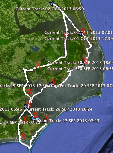
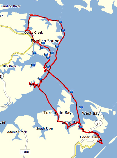
On the Watertribe forum Kiwibird says that the NC event will be a 2 and 1/2 day circumnavigation of Cedar Island all the way down to the Beaufort waterfront.  (Bruce and I did this circumnavigation back in '07 on a relaxed six day trip with overnight stops on Core Sound, Pamlico Sound, Oriental and Beaufort.  It is a beautiful trip that includes shallow sounds, winding rivers, a canal, wide open Pamlico Sound and the wind swept dunes of the Core Banks. You can read about our trip here.   And here is a photo album of the trip. ) Below is a little of Sandybottom's description of the tentative plan....

Here is what we are planning (nothing final or approved by WaterTribe yet).  Boat inspections/Captain Meeting Thursday afternoon/evening.  Race start Fri 7am, end Sun 2pm.   Awards ceremony and banquet Sun 1pm.  Checkpoint on Beaufort waterfront.  All WaterTribe rules in effect, Spot manditory.

The route is approximately 100 miles, Cedar Island, Neuse River, Harlow Canal, around Beaufort, Harkers Island, up Core Sound back to Cedar Island.

We plan to promote it as a weekend for family and friends as well.  The Oakracoke ferry leaves from Cedar Island, Beaufort is a short drive to watch participants at the CP, or visit the maritime museum etc....

Sounds like a great event.  

Kiwibird also points out that the SPOT locator beacon, which they will require for the NC event, is available free (where was this deal last year when I bought mine??) if you sign up for the basic and tracking service by March 27.  Check it out at here.

-Steve


Monday, March 23, 2009

under sail

I got a note from Ross asking if I had any photos of Spartina under full sail.  He's building a Pathfinder, you can see some of his work on his blog.  Looks like he is doing some nice work.
I do have a few photos, but not as many as I would like.  I'm always in the boat when she is under sail, so most of my photos have a cockpit point of view.  Maybe on this upcoming trip I'll drop Bruce off on a pier or islet with a long lens and get some serious photos of her under sail.  These photos were made in 2006 when I first launched Spartina (above) and a few days before the launch (below).  I still had not got the rigging quite right, in fact I messed around with the rigging throughout that first summer of sailing.  So in these photos the sails are not set properly, but at least they'll give you an idea of what she looks like under sail. 
On launch day my brother Mike flew in to town to help celebrate.  That is him peeking from under the jib in the top photo.  As we sailed down the Elizabeth River (a great sail by the way, with the rigging not quite right we still hit almost 6 knots according to the gps) we saw a tall ship coming our way.  It was the  Kalmar Nyckel, the state ship of Delaware (bottom photo).  She was headed to the Hampton Blackbeard Pirate Festival.  On board was a friend of mine with a nice long lens.  He recognized me and shot a few photos, including the one at the top.  A nice chance meeting out on the water that left me with a few photos to remember Spartina's launch day.  


Thursday, March 19, 2009

clouds, rain and sun


This photo was from last June, but it is how I feel right about now.  Four days of rain, one day of sun, now pouring rain again.  When will the sun break through?
Doing small jobs getting ready for the cruise.   Decided to use the Bridge Point Marina in New Bern for the end point of the trip.  My BoatUS card will get us a discount on dockage, plus if we stay at the hotel I know from my two visits to New Bern that an Outback Steakhouse is within walking distance!
I've been adding to the food supply bit by bit.  Plenty of lunches and breakfasts on hand now.  Menu is shaping up with some nice variety.  Also picked up a battery-powered charger for the cell phones.  Along with satellite beacons, vhf radios and flares, I include a cell phone as part of our emergency kit.  It is surprising where you can sometimes get a signal.


Stopped by a tackle shop to look for a fishing lure used on the gulf coast for trout and puppy drum (or redfish, as they would say down there).  It is a lure called a Corky that uses cork covered in soft plastic.  I've been wanting to give it a try.  The old guy at the tackle shop spent so much time lecturing me on why this product wouldn't be available for a couple of years ("Do you realize how much it costs to warehouse this stuff?") that he did not realize he was leaning on a display case that had them all right there!  Didn't buy any that day (didn't want to hurt the guy's feelings) but will stop in to pick up one or two up this spring.


Looking at the forecast this weekend is out for sailing.  Small chance the following weekend.
-Steve

Tuesday, March 17, 2009

fog on the harbor


Five days now of fog, mist and rain.  I took this picture yesterday morning but believe me it looked the same today.  I was at Waterside in Norfolk looking across the river to Portsmouth. The ferry runs between the two cities.  The tug was waiting for a navy ship going in to the dry docks.
I do a lot of my day sailing out there.  It's nice to sail for a few hours, come in to the marina to tie up for $5 bucks and walk to D'egg Diner for lunch.  Then back out on the water for some afternoon sailing.
This picture reminds me of historical photographs of the waterfront with ferries and workboats.  It also reminds me of 30 years ago when Bruce and I would go down to the San Diego waterfront with cameras and tripods to make pictures on Tri-X film.   This photo would have looked nice on black and white film, printed dark with a little extra contrast, the highlights of ferry bleached to bring them out a little.
Got an email from Bruce checking on travel dates for our fall trip up Chesapeake Bay to the Mid-Atlantic Small Craft Festival.  We probably should get those details worked out soon.
I hope this weather clears tomorrow.

-Steve